Maps Site map
  Maps > Asia > Regional Maps >Western Asia
Site Map  

  Record   1   to   7  of   7

Regional Asian maps of the Western Asia region from the Maps ETC collection. This includes physical and political maps, early history and empires, climate maps, relief maps, population density and distribution maps, cultural maps, and economic/resource maps.

The Empire of Timurlane, 1398
A map of the Asian empire of Timurlane the Mongol (Timur or Tamerlane) from 1369 to its dissolution in 1505. The map shows the boundaries of the empire at its greatest extent, and notes the areas of destruction (Smyrna and Delhi) and territories that...

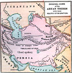
Original Home of the Aryan Tribes, 1500 B.C.
A map of Persia and surrounding regions showing the seat and original territories of the Aryan tribes and migration routes to India and Europe....

The Western Frontier of India and Neighbouring Countries, 1805–1910
A map of the western frontier of India, Afghanistan, Persia, and the southern Russian Empire between 1805 and 1910. The map is color–coded to show the territories of the British and Russian Empire at the time, and the spheres of influence of th...

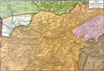
North Afghanistan between the Rivers Indus, Heri Rud, and Oxus, 1886
A map of North Afghanistan between the Rivers Indus, Heri Rud, and Oxus. The map is color–coded to differentiate between the different countries in the area. ...

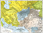
Persia, Afghanistan, and Turkey in Asia , 1899
A map from 1899 showing the extent of the Turkish Ottoman Empire from the Black Sea south to the western coast of the Persian Gulf and along the eastern coast of the Red Sea to the Gulf of Aden. The map also shows the Arabian Peninsula and the border...

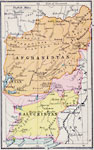
Afghanistan and Baluchistan, 1920
A map from 1920 of Afghanistan and Baluchistan. At this time, Baluchistan was part of British India, and the map shows the districts of Baluchistan, Kachh, and the British controlled district around Quetta. Baluchistan became part of Pakistan in 1947...

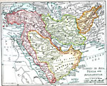
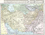
Persia, Afghanistan, and Baluchistan, 1920
A map from 1920 of Persia, Afghanistan, and Baluchistan showing the political boundaries at the time. The map shows capitals and major cities, ports, railways, mountain systems, plateaus, deserts, rivers, and coastal features of the region. A grid ke...


  Maps > Asia > Regional Maps >Western Asia
Site Map  

Maps is a part of the Educational Technology Clearinghouse
Produced by the Florida Center for Instructional Technology © 2009
College of Education , University of South Florida