Record
11 to
20 of
228
A collection of historic and contemporary maps of England, Scotland, and Wales, including historic divisions, empires and kingdoms, detailed travel maps, climate maps, population density and distribution maps, vegetation maps, and economic/resource maps.
|
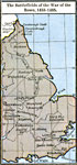
England in the War of the Roses,
1455–1485
Map of England, Wales, and Scotland during the War of the Roses (1453–1487) between the House of York (White Rose) and the House of Lancaster (Red Rose). This map shows major cities of the time, major river ways, topography, political boundarie...
|
|
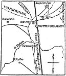
England During the Wars of the Roses,
1455–1485
A map of England during the Wars of the Roses (1453–1487), a civil war between the House of Lancaster (Red Rose) and the House of York (White Rose) for the throne of England. The ultimate Lancaster victory led to the Tudor Dynasty. The map show...
|
|
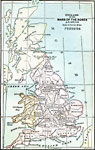
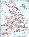
England and Wales,
1485 –1603
A map of England and Wales during the Tudor Dynasty (1485–1603) founded by Henry VII and ending at the death of Elizabeth I. The boundaries of the Welsh Counties are given as settled by the Laws in Wales Act of 1543 during the reign of King Hen...
|
|
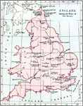
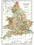
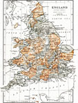
England during the Tudor Period,
1485–1558
A map of England and Wales during the Tudor Period, from the ascension of Henry Tudor (Henry VII) in 1485 at the end of the War of the Roses, to the death of Elizabeth I in 1603. The map shows major cities of the time, major river ways, topography, a...
|
|
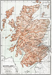
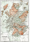
Scotland during the Tudor Period,
1485–1558
Map of Scotland during the Tudor Period (1485 to 1558). This map shows major cities of the time, major river ways, topography, and political boundaries. Scale in English miles. There is an insert of the Shetland Isles and the Orkney Isles....
|
|
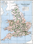
England and Wales under the Tudors,
1485–1603
A map of England and Wales under the Tudors (1485–1603). This map is color–coded to show the two ecclesiastical provinces of the Church of England, the Province of York in the north, and the Province of Canterbury in the south. The bounda...
|
|
England during the Stuart Period,
1603–1714
This is a map of England and Wales during the Stuart Period, from the ascension of King James I in1603 to the death of Queen Anne in 1714. This map shows major cities of the time, major river ways, topography, and political boundaries. Several import...
|
|
Scotland during the Stuart Period,
1604–1714
This is a map of Scotland during the Stuart Period (1603 to 1714). The map shows major cities of the time, major river ways, topography, and political boundaries. Scale in English miles. There is an insert of the Shetland Isles and the Orkney Isles....
|
Maps ETC is a part of the Educational Technology Clearinghouse
Produced by the Florida Center for Instructional Technology © 2009
College of Education, University of South Florida