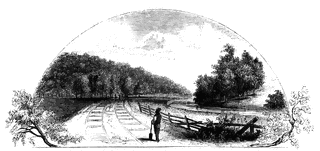
Battleground near Fort Anne
| View Cart ⇗ | Info

Battleground near Fort Anne. This sketch was taken from the rail-road, looking north. The forest upon the left is the ‘thick wood’ of the Revolution, but on the right cultivated fields have taken the place of the forest to a considerable extent. On the right is seen the Champlain Canal, here occupying the bed of Wood Creek. The fence on the left indicates the place of the public road between Fort Anne and Whitehall. When this sketch was made (1848) the rail-road was unfinished.
Galleries
1763-1788 American Revolution PlacesSource
Benson J. Lossing, The Pictorial Field-Book of the Revolution (New York: Harper & Brothers, 1851)I:141
Downloads
2400×1138, 2.6 MiB
1024×485, 151.3 KiB
640×303, 63.1 KiB
320×151, 17.3 KiB