Battleground near Fort Anne. This sketch was taken from the rail-road, looking north. The forest upon the left is the 'thick wood' of the Revolution, but on the right cultivated fields have taken the place of the forest to a considerable extent. On the right is seen the Champlain Canal, here occupying the bed of Wood Creek. The fence on the left indicates the place of the public road between Fort Anne and Whitehall. When this sketch was made (1848) the rail-road was unfinished.

Battleground near Fort Anne

Battleground near Fort Anne. This sketch was taken from the rail-road, looking north. The forest upon…

"Battle ground at Concord. This view, looking southeast, is from the road leading to the village, by the way of the North Bridge, to the residence of Mr. Prescott Barrett. The point from which the sketch was made is upon an elevation a little north of that where the militia assembled under Colonel Barrett. The stream of water is the Concord, or Sudbury River. The site of the North Bridge is at the monument seen in the center of the picture. The monument stands upon the spot where the British were stationed, and in the plain, directly across the river from the monument, is the place where Davis and Hosmer, of the American militia, were killed. The house, the roof and gable of which are seen in the distance, just on the left of the largest tree, was the residence of the Reverend Dr. Ripley (afterward a chaplain in the army) at the time of the skirmish. It is upon the road elading to Concord village, which lies nearly half a mile beyond."—Lossing, 1851

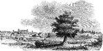
Battleground at Concord

"Battle ground at Concord. This view, looking southeast, is from the road leading to the village, by…
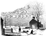
"View at the Spring; Hobkirk's Hill. It is at the hed of a ravine, scooped out of the northeastern slope of Hobkirk's Hill. The noble trees which shadow it are tulips, poplars, and pines. The house seen on the top of the hill, toward the left, is the residence of William E. Johnson, Esq., president of the Camden Bank. A few yards below the spring a dike has been cast up, across the ravine, by which a fine duck pond is formed, and adds beauty to the scene, in summer."—Lossing, 1851

Hobkirk's Hill

"View at the Spring; Hobkirk's Hill. It is at the hed of a ravine, scooped out of the northeastern slope…

The Battle of Kings Mountain, October 7, 1780, was an important Patriot victory in the Southern campaign of the American Revolutionary War.

View at King's Mountain Battleground

The Battle of Kings Mountain, October 7, 1780, was an important Patriot victory in the Southern campaign…

A view of the Battle of Lexington during the American Revolutionary War.

Battle of Lexington

A view of the Battle of Lexington during the American Revolutionary War.

The Battle of Monmouth was an American Revolutionary War battle fought on June 28, 1778 in New Jersey.

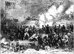
Battleground at Monmouth

The Battle of Monmouth was an American Revolutionary War battle fought on June 28, 1778 in New Jersey.

"View of the battle-ground near Princeton. This view, looking north, is from the carriage gate of Mr. John Clarke, owner of the house in which General Mercer died, which is situated about seventy rods from the Trenton turnpike. That dwelling is represented in the foreground of the picture, on the extreme right. The distant view includes almost the whole field of action. Near the center of the picture, over the head of the dark figure, is seen the house of William Clark, and his out-buildings. The barn, a little more to the left, with a tree in front, is upon the spot from whence Mercer rushed forward to the hedge-fence. That fence was upon the line of the present turnpike, denoted in the sketch by the fence passing down the slope beyond the large tree on the extreme left. The 'high ground' for which both parties were aiming, to secure advantage, is seen in the extreme distance. The dark spot between the tree in the second field and the barn denotes the spot where Mercer fell. The house of William Clark, in the distance, is about a quarter of a mile from the one in the foreground, where Mercer died. The hollow between the two houses was the space between the belligerents when Washington advanced to the support of Mercer. The place of conflict is about a mile and a quarter south of Princeton. The turnpike passes directly through it."—Lossing, 1851

Princeton battle-ground

"View of the battle-ground near Princeton. This view, looking north, is from the carriage gate of Mr.…