Clipart tagged: ‘forts’
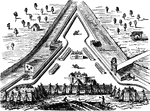
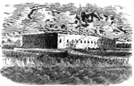
!["View from the site of Fort Cornwallis. Fort Cornwallis occupied the ground in the rear of the Episcopal church, now a grave-yard. This view is from within the inclosure, looking northeast, and includes a portion of Schultz's bridge, the Savannah River, and Hamburg upon the opposite bank. In the foreground is seen portions of the church-yard wall, and upon the brink of the river below are [African Americans] employed in placing bales of cotton upon the wharves for transportation to the sea-coast. The wharves are two stories in height, one to be used at low water, the other when the river is 'up.' There were remains of the ditch and embankments of the fort within the grave-yard when I was there; and the trench leading to the water-gate, where the 'Pride-of-India tree is seen, was very visible."—Lossing, 1851](https://etc.usf.edu/clipart/14100/14143/ft-cornwalli_14143_mth.gif)
Fort Cornwallis
"View from the site of Fort Cornwallis. Fort Cornwallis occupied the ground in the rear of the Episcopal…
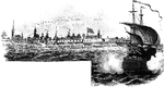

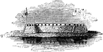
Fort Hatteras
View of the camp of the twentieth Indiana Regiment; also of Fort Hatteras and the anchorage at Hatteras…
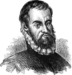
Pedro Menéndez de Avilés
Pedro Menéndez de Avilés, a Spanish soldier who landed at and named St. Augustine and attacked the…
Fort Moultrie
"View at Fort Moultrie. This view is from the southwestern angle of Fort Sullivan, looking toward Jame's…
Fort Pulaski
Fort Pulaski, on Cockspur Island at the entrance to the Savannah River, Georgia, was built by the United…
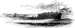
Fort Watson
"Site of Fort Watson."—Lossing, 1851 The Siege of Fort Watson was an American Revolutionary War confrontation…