Clipart tagged: ‘terrain symbol’
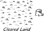
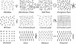
Cleared Land Vegetation Topography Symbol
Cleared land vegetation topography symbol used in map drawing and drafting.
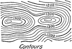
Contour Relief or Terrain Topography Symbol
A terrain or relief topography symbol for contours illustrating elevation of the land commonly used…
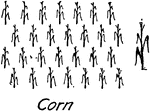
Corn Vegetation Topography Symbol
Topography conventional symbol for corn used in map drawing and drafting.
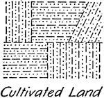
Cultivated Land Vegetation Topography Symbol
A drafting topography vegetation symbol for cultivated land.
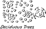
Deciduous Trees Vegetation Topography Symbol
Vegetation topography symbol for deciduous trees convention in drafting and map drawing.
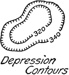
Depression Contour Relief or Terrain Topography Symbol
A depression contour relief or terrain topography for drafting and map drawing illustrating lower land…
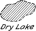
Dry Lake Topography Symbol
Topography symbol for dry lake conventionally used in map drawing and drafting.
Everglade Trees Vegetation Topography Symbol
A vegetation Everglade tree for topography symbol used in map drawing and drafting.
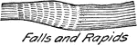
Falls and Rapids Topography Symbol
A commonly used drafting and map drawing conventional symbol for falls and rapids.
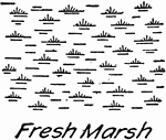
Fresh Water Marsh Topography Symbol
Topography map symbol for fresh water marsh used in drafting and map drawing.
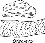
Glaciers Topography Symbol
A conventional glacier topography symbol commonly used in drafting and map drawing.
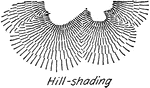
Hill Shading Relief or Terrain Topography Symbol
A standard topography symbol commonly used for shading hills.
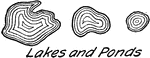
Lakes and Ponds Topography Symbol
A common topography symbol for lakes and ponds used in drawing maps and drafting.
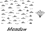
Meadow Vegetation Topography Symbol
A conventional topography vegetation symbol for meadow used in map drawing and drafting.
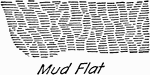
Mud Flat Relief or Terrain Topography Symbol
Topographical symbol for mud flat, or mud deposit from the mud, used in drafting and map drawing.
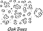
Oak Trees Vegetation Topography Symbol
A conventional oak tree vegetation symbol used in map drawing and drafting.
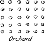
Orchard Vegetation Topography Symbol
A conventional vegetation topography for orchard commonly used in map drawing and drafting.
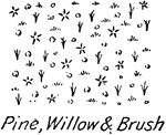
Pine Willow and Brush Vegetation Topography Symbol
Conventional vegetation topography symbol for pine, willow and brush.
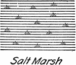
Salt Water Marsh Topography Symbol
A conventional topographical water feature for salt water marsh used in drafting and map drawing.
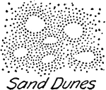
Sand Dunes Relief or Terrain Topography Symbol
A map drawing and drafting topography symbol illustrating sand dune.
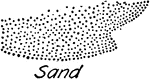
Sand Relief or Terrain Topography Symbol
Conventional sand topography symbol commonly used in map drawing and drafting.
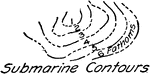
Submarine Contours Topography Symbol
A submarine contour, underwater low elevation, conventional topographic symbol used for drafting and…
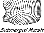
Submerged Marsh Topography Symbol
Conventional topography symbol for submerged marsh used in drafting and map drawing.
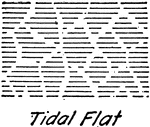
Tidal Flat Topography Symbol
A tidal flat topography conventional symbol commonly used in drafting and map drawing.
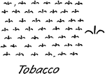
Tobacco Vegetation Topography Symbol
A conventional map drawing and drafting topography symbol for tobacco.
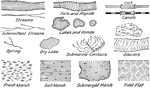
Vegetation Topography Symbol
A series of conventional topography symbol for vegetation used in map drawing and drafting.
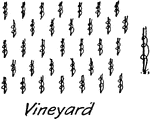
Vineyard Vegetation Topography Symbol
A common topography vegetation symbol for vineyard used in map making and drafting.
Water Feature Lock Topography Symbol
A water lock conventional symbol used in map drawing and drafting. A lock is used to lower or raise…
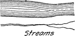
Water Features Topography Symbol
A series of topographical symbols for water features commonly used in drafting and map drawing.
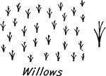
Willows Vegetation Topography Symbol
A map drawing or drafting conventional vegetation symbol for willow.