Contour lines never cross on the ground but in rare cases as an overhanging cliff they may cross on the map.

Contour Lines

Contour lines never cross on the ground but in rare cases as an overhanging cliff they may cross on…
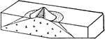
A contour about to cross a stream runs up one side and down the other, making a V where it crosses, the angle of the V pointing up stream. Contour lines representing spurs between stream lines are generally U shaped with the bottom or rounded part of the U pointing down hill.

Contour Lines

A contour about to cross a stream runs up one side and down the other, making a V where it crosses,…

"Cosmas lived in the sixth Christian century. In the cut here reproduced from his Topography, he ridicules the idea of a round earth with people on the under side whose heads hand downwards. The views of Cosmas as to the existence of an antipodal people had defenders throughout the medieval centuries."—Myers, 1905

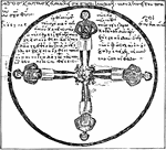
The Antipodes in Derision

"Cosmas lived in the sixth Christian century. In the cut here reproduced from his Topography, he ridicules…
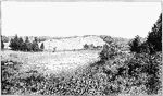
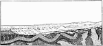
"View of the southeastern slope of the eastern twin of Orenaug Hill. Fault scarps bound the hummocky surface of the block on the northeast and west; the courses of the scarps follow the fringes of trees." -Walcott, 1901

Fault Scarp Slope

"View of the southeastern slope of the eastern twin of Orenaug Hill. Fault scarps bound the hummocky…
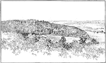
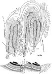
"Fault scarps of Orenaug Hill (floating block topography). The view is taken from the top of a cliff in the eastern twin hill." -Walcott, 1901

Fault Scarps

"Fault scarps of Orenaug Hill (floating block topography). The view is taken from the top of a cliff…
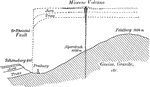
Diagrammatic section through the Freiburg region showing the former and present topography and the extensive erosion.

Freiburg Region

Diagrammatic section through the Freiburg region showing the former and present topography and the extensive…

"Diagram illustrating the position of the groundwater surface (the dotted line) in a region of undulating topography." -Salisbury, 1919

Groundwater Position

"Diagram illustrating the position of the groundwater surface (the dotted line) in a region of undulating…

The diagram shows the source of groundwater: water falls into porous ground (a), flows underground to be brought to the surface in another location.

Groundwater Source

The diagram shows the source of groundwater: water falls into porous ground (a), flows underground to…
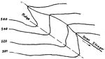
"Unit orographic blocks in granite, near the knife works, Hotchkissville. a Area over downthrown block." -Walcott, 1901

Orographic Blocks

"Unit orographic blocks in granite, near the knife works, Hotchkissville. a Area over downthrown block."…

A barrier reef is a coral reef that is far from land.

Barrier Reef

A barrier reef is a coral reef that is far from land.

A fringing reef is a coral reef that is close to land.

Fringing Reef

A fringing reef is a coral reef that is close to land.

A diagram of the relief features: mountain, plateau, plain, ocean basin, ocean deep, and volcano.

Relief Features

A diagram of the relief features: mountain, plateau, plain, ocean basin, ocean deep, and volcano.

Diagrammatic sections to represent the development of the Rhine Graben and its present structural and topographic features.

Rhine Graben

Diagrammatic sections to represent the development of the Rhine Graben and its present structural and…

Two cases of springs: "In one, the water descends through the porous bed e to the layer d, which is relatively impervious. The water flows along this layer until it comes to the surface, and there the water flows out as a spring, s'. In the other, the water moves underground through the porous layer b, under pressure, until it reaches a crack which leads up to the surface...s." -Salisbury, 1919

Springs

Two cases of springs: "In one, the water descends through the porous bed e to the layer d, which is…

"Ideal section of part of the earth's crust, with landscape above. Granite and other crystalline rocks appear with irregular outlines at the bottom of the section; over them are stratified rocks, partly bent and partly flat. The forms of the landscape are related to the arrangement of the rocks." -Gilbert, 1910

Stratified Layers

"Ideal section of part of the earth's crust, with landscape above. Granite and other crystalline rocks…
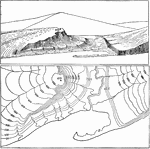
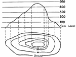
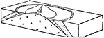
The top image is a sketch of earth contours. The bottom image is that land translated into a topographical map.

Topography

The top image is a sketch of earth contours. The bottom image is that land translated into a topographical…
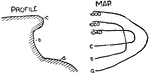
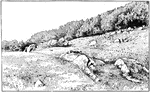
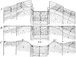
"Map and section of trap ridges near Woodbury. The topography is indicated by sketched contours, with hachures for trap bluffs. The lower sandstone slopes are all covered, and the northern bluff of the western group of ridges is quite buried in drift. The crystalline rocks appear on the east. The section suggests an interpretation of the surface forms." -Walcott, 1901

Trap Ridges

"Map and section of trap ridges near Woodbury. The topography is indicated by sketched contours, with…

Vertical interval is the difference in elevation between adjacent contours.

Vertical Interval

Vertical interval is the difference in elevation between adjacent contours.

A woman drawing a picture of a map.

Woman Drawing

A woman drawing a picture of a map.