Historic maps for students & teachers
Welcome to ETC's collection of historic maps. Here you will find over 5,000 maps representing many different time periods. A friendly license allows teachers and students to use up to 25 maps in non-commercial school projects without further permission. All maps are available as GIF or JPEG files for screen display as well as in PDF for printing. Use the GIF or JPEG maps for classroom presentations and student websites. Use the PDF maps for displays, bulletin boards, and printed school reports.
Two ways to get started:
![]()
-
Browse Galleries. Select a region from the list below to see a list of all the available galleries of maps for that region. Then select the gallery you are interested in and browse through thumbnails of available maps. This will give you a good idea of what is included in this map collection.
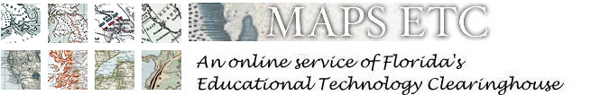
Africa
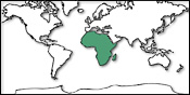
Antarctica
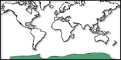
Asia
Australia

Europe
North America
South America
United States
World Maps, including separate galleries of maps for intercontinental regions; North, South, East, and West Hemispheres; Arctic, Atlantic, Pacific, and Indian Oceans, and the Mediterranean Sea. Also includes multi-continental maps, such as maps that contain both North and South America, Eurasia, and more.
- Search Database. The maps database is updated before the sitemap and galleries, so you may be able to find maps here that are not yet included in the gallery menus. Last update: July 14, 2009