Maps Site map
  Maps > Asia > Regional Maps >Northern Asia
Site Map  

  Record   1   to   3  of   3

Regional Asian maps of the Northern Asia region from the Maps ETC collection. This includes physical and political maps, early history and empires, climate maps, relief maps, population density and distribution maps, cultural maps, and economic/resource maps.

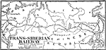
Trans-Siberian Railway, 1891–1918
A map of the Trans–Siberian Railway system from Petrograd (St. Petersburg) to Vladivostok on the Pacific. The map shows the en route cities of Moscow, Omsk, Irkutsk, Chita, and Harbin, with spur routes to Stretensk, Khabarovsk, and Port Arthur ...

Russia in Northern and Central Asia, 1904
A map from 1904 of northern and central Asia showing the political boundaries at the time. The primary focus of this map is the area of the Russian Empire in Asia, showing its extent from the Ural Mountains in Europe to the Pacific, the frontiers wit...

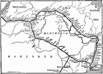
Eastern Trans-Siberian Railroad, 1918
A map from 1918 of the Trans-Siberian Railroad from Lake Baikal to Vladivostok on the Pacific. This section, except for Vladivostok and Kharbin (Harbin), was largely controlled by the Bolsheviki during World War I. The map shows the route of the tru...


  Maps > Asia > Regional Maps >Northern Asia
Site Map  

Maps is a part of the Educational Technology Clearinghouse
Produced by the Florida Center for Instructional Technology © 2009
College of Education , University of South Florida