|
|
|
| Maps > Europe > Germany |
Historic and contemporary maps of Germany, including political and physical maps, early empires, WWI, city plans, and battle plans.

|
Central Northern Germany,
1920 |
|
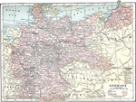
Germany,
1920 |

|
Germany,
1920 |

|
Germany,
1920 |
|
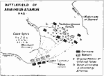
Battle of Teutoburg Forest ,
A.D. 9 |

|
Plan of Cathedral at Würms,
AD 1000–1025 |

|
Plan of Cathedral at Aix-la-Chapelle,
AD 796 |

|
Plan of Cathedral at Mainz,
AD 976 |
|
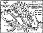
Battle of Blenheim,
August 13, 1704 |
|
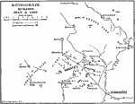
Königgrätz ,
March 7, 1866 |
| First | Previous |
| Maps > Europe > Germany |
Maps ETC is a part of the Educational Technology Clearinghouse
Produced by the Florida Center for Instructional Technology © 2009
College of Education, University of South Florida