Maps Site map
  Maps > Europe > Sweden
Site Map  

  Record   1   to   2  of   2

Historic and contemporary maps of Sweden for use in the K-12 classroom.
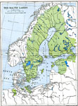
The Baltic Lands, 1661
A color–coded map showing the dominions of Sweden in 1661 extending around the Gulf of Bothia to include Finland and Carelia, Ingria, Esthonia, Ösel, Livonia, and West Pomerania on the Baltic Sea, and potions of Mecklenburg and Bremen.. ...

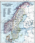
Sweden, Norway & Denmark, 1910
Map shows the Scandinavian countries of Sweden, Norway, and Denmark in 1910, with a reference key to the lands and districts of Norway and Sweden. The map shows major cities and towns, railways, rivers, lakes, terrain, and coastline....


  Maps > Europe > Sweden
Site Map  

Maps ETC is a part of the Educational Technology Clearinghouse
Produced by the Florida Center for Instructional Technology © 2009
College of Education, University of South Florida