Record
31 to
40 of
228
A collection of historic and contemporary maps of England, Scotland, and Wales, including historic divisions, empires and kingdoms, detailed travel maps, climate maps, population density and distribution maps, vegetation maps, and economic/resource maps.
|
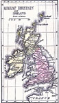
England during the Brunswick Period,
1714–1901
This is a map of England and Wales at the beginning of the Brunswick Period (1714–1901). The Brunswick period began at the ascension of George I (House of Hanover) as King of Great Britain and Ireland, succeeding Queen Anne (House of Stuart), a...
|
|
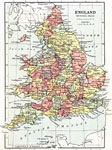
Scotland during the Brunswick Period,
1714–1910
This is a map of Scotland during the Brunswick Period (House of Hanover – 1714 to 1910). The map shows major cities of the time, major river ways, topography and political boundaries. Scale in English miles. There is an insert of the Shetland I...
|
|
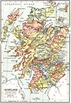
Central Britain,
1715–1745
A map of Central Britain during the time of the First Jacobite Rebellion (1715) led by James Francis Edward Stuart (the Old Pretender) to the Second Jacobite Rebellion (1745) led by Charles Edward Stuart (the Young Pretender). The map shows the route...
|
|
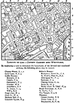
London - Covent Garden and Westward,
1720
A detailed map of London Circa1720 showing major roads, the River Thames parks, government buildings and locations pertaining to the times of Joseph Addison (1672 – 1719) west of Covent Gardens. "By employing a ruler to determine the bound...
|
|
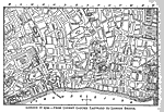
London - Covent Garden and Eastward to London Bridge,
1720
A detailed map of London Circa1720 showing major roads, the River Thames, parks, government buildings and locations pertaining to the times of Joseph Addison (1672 – 1719) east of Covent Gardens to London Bridge. "By employing a ruler to ...
|
|
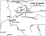
Land of Burns,
1759–1796
A map showing the countryside of the Scottish poet Robert Burns (1759–1796). The map shows the town of Alloway Kirk (birthplace) and Burns' Cottage south of Ayr, Mount Oliphant, where he grew up, and Kilmarnock, where his first volume of poetry...
|
|
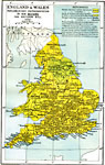
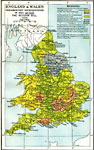
England and Wales,
1832
A map of England & Wales, subtitled "Parliamentary Representation in 1832 Before The Reform Bill." The Reform Act made wide–ranging changes in the electoral system in the United Kingdom due, in part, to the growth of large and powerfu...
|
|
England and Wales,
1832
A map of England & Wales, subtitled "Parliamentary Representation in 1832 After The Reform Bill." The Reform Act made wide–ranging changes in the electoral system in the United Kingdom due, in part, to the growth of large and powerful...
|
|
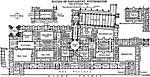
Houses of Parliament, Westminster; Plan of Principal Floor,
1836–1868
This is the Plan of Principal Floor of the Houses of Parliament in Westminster, England. Other wise known as Westminster Palace, It is an example of Modern English Architecture. The architect was Sir Charles Barry. Construction lasted from 1836 to 18...
|
Maps ETC is a part of the Educational Technology Clearinghouse
Produced by the Florida Center for Instructional Technology © 2009
College of Education, University of South Florida