|
|
|
| Maps > Europe > Italy |
Historic and contemporary maps of Italy, including political and physical maps, early empires, WWI, city plans, and battle plans.

|
The Neighborhood of Rome,
100 AD |

|
Plan of San Ambrogio,
1000–1200 |

|
Plan of San Michele, Pavia,
1000–1200 |
|
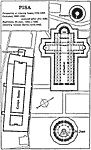
Plan of the Campanile de Pisa,
1068–1509 |

|
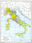
Italy,
1175 A.D. |

|
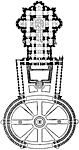
Plan of San Nicola at Bari,
12th Century |

|
Map of N. E. Italy showing the battlefields in the Franco-Italian War,
1521–1598 |
|
Plan of St Peter's at Rome,
1546–1564 |
|
Italy,
1600 |
|
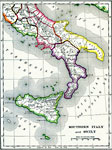
Southern Italy and Sicily,
1600–265 BC |
| Next | Last |
| Maps > Europe > Italy |
Maps ETC is a part of the Educational Technology Clearinghouse
Produced by the Florida Center for Instructional Technology © 2009
College of Education, University of South Florida