|
|
|
| Maps > Miscellaneous Maps > Miscellaneous |
A collection of odds and ends, including building plans and general typical maps.
|
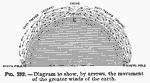
Profile of the Earth's Greater Wind Patterns,
1910 |
| Maps > Miscellaneous Maps > Miscellaneous |
Maps ETC is a part of the Educational Technology Clearinghouse
Produced by the Florida Center for Instructional Technology © 2009
College of Education, University of South Florida