Maps Site map
  Maps > Globes and Multi-continent > Complete Maps
Site Map  

  Record   31   to   40  of   316

A collection of world and multi-continent maps, including various projections, hemispheric maps, physical and political maps, early known world maps, climate maps, relief maps, ocean current maps, population density and distribution maps, vegetation maps, and economic/resource maps.

Chart of Winds, 1873
A world map from 1873 showing the prevailing global wind patterns. The arrows on the map fly with the winds, and indicate regions where winds blow seasonally in one direction or another (monsoons of India for example). This map shows regions of calms...

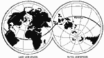
Global View of the Land Sphere and Water Sphere, 1873
A map from 1873 showing the "Land Hemisphere"(landmasses), the &Water Hemisphere" (oceans), the Equator, and the major continental mountain systems....

Tidal Chart of the World, 1873
A map of the world from 1873 showing the progress of the wave of high water and the hour of high water in Greenwich time at new and full moon. The distance of any two lines is the distance traversed in an hour....

World Geographical Circles, 1882
A map of the world showing the geographical circles....

World Hemispheres, 1882
A world map from 1882 showing the Western and Eastern hemispheres. The map includes small images of double–hemispheres showing the Pacific and the Atlantic oceans, as well as polar views of the Northern and Southern hemispheres....

World Zone Limits, 1882
Map of the world showing the limits of the zones....

The World in Hemispheres, 1883
A world map from 1883 showing the Western and Eastern hemispheres. The map includes small images of double–hemispheres showing the Pacific and the Atlantic oceans, as well as polar views of the Northern and Southern hemispheres....

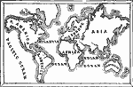
The World as known in our own day, 1884
A sketch map of the world from 1884 showing the continents and oceans....

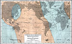
Magnetic Declination and Inclination, 1885
A world map from 1885 showing the Earth's east–west declination of the magnetic poles from the geographic poles for the Epoch 1882. This map shows lines of declination (solid), lines of inclination, or dip of the compass needle from vertical (d...

Chart of Volcanoes, Active and Extinct, 1885
A map from 1885 showing the regions of active and extinct volcanic activity across the earth. The map shows prominent volcanoes with names underlined in red, regions of volcanic activity such as The Great Volcanic Circle (Ring of Fire) of the Pacific...

First Previous Next Last


  Maps > Globes and Multi-continent > Complete Maps
Site Map  

Maps ETC is a part of the Educational Technology Clearinghouse
Produced by the Florida Center for Instructional Technology © 2009
College of Education, University of South Florida