|
|
|
| Maps > Globes & Multi-Continent > Regional Maps >Regional Mediterranean |
Regional Globes & Multi-Continental maps of the Regional Mediterranean region from the Maps ETC collection. This may include physical and political maps, early history and empires, climate maps, relief maps, vegetation maps, population density and distribution maps, cultural maps, and economic/resource maps.

|
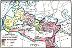
Division and Subdivision of the Roman Empire,
A.D. 395 |
|
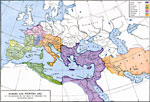
Europe and Western Asia at the beginning of the Reign of Theodoric the Ostro-goth,
A.D. 494 |

|
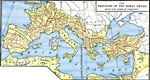
Provinces of the Roman Empire,
About the beginning of the Christian era (A.D.) |
|
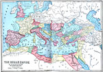
Roman Empire,
AD 101–200 |
|
The Provinces of the Roman Empire within the Years of Conquest,
AD 116 |

|
The Roman Empire in its Greatest Extent,
AD 116 |

|
Roman Empire in the Time of Trajan,
AD 117 |

|
The Roman Empire Under Trajan,
AD 117 |

|
Roman Empire at the death of Augustus,
AD 14 |
|
The Roman Empire under Diocletian ,
AD 284–305 |
| First | Previous | Next | Last |
| Maps > Globes & Multi-Continent > Regional Maps >Regional Mediterranean |
Maps
is a part of the
Educational Technology Clearinghouse
Produced by the
Florida Center for Instructional Technology
© 2009
College of Education
,
University of South Florida