Maps Site map
  Maps > North America > Regional Maps
Site Map  

  Record   181   to   184  of   184

Regional maps of North America, which include several selections of countries and nations displaying physical and political features, economy, discovery, and more.

Nouvelle France, Nouvelle Angleterre, and Nouvelle Ecosse, Late 1600s
A facsimile of a map from Covens and Mortier (Allard atlases of the late 1600s) of Canada and New England. The map shows Canada or Nouvelle France, Mer Douce (Lake Huron), Nouvelle Angleterre (New England), Nouvelle Ecosse (Nova Scotia), and C. Raze ...

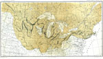
The Terminal Moraine Region of North America, Second Glacial Epoch
A map from 1882 of the drift bearing area in the northern United States and Canada, showing the generalized directions of glacial movement, the direction of glacial striae, and the locations of prominent terminal moraines. Scale is one inch equals 15...

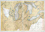
The Terminal Moraine (Central), Second Glacial Epoch
A map of the terminal moraine of the second glacial epoch in the Great Lakes region, including the drift bearing area, the generalized directions of glacial movement, the direction of glacial striae, and the locations of prominent terminal moraines. ...

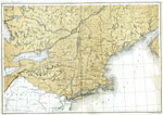
The Terminal Moraine (Eastern), Second Glacial Epoch
A map showing the terminal moraine of the second glacial epoch east of the Great Lakes region, including the glacial landscape features of Cape Cod and Nantucket, Long Island, the Catskills and Finger Lakes, and the extreme terminal moraine described...

First Previous


  Maps > North America > Regional Maps
Site Map  

Maps ETC is a part of the Educational Technology Clearinghouse
Produced by the Florida Center for Instructional Technology © 2009
College of Education, University of South Florida