Record
1 to
10 of
73
Historic and contemporary maps of the United States, including physical and political maps, early exploration and colonization period, territorial expansion maps, climate maps, relief maps, population density and distribution maps, vegetation maps, and economic/resource maps.
|
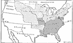
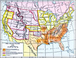
Slave and Free Areas after the Missouri Compromise,
1820
A map of the United States at the time of the Missouri Compromise (1820) showing the free states and territories, slave states and territories, the British and Spanish possessions at the time, and the Oregon Country....
|

|
The United States,
1821
A map of the United States in 1821 showing the states and territories which either accepted or abolished slavery after the Missouri Compromise of 1820. The map is color–coded to show absolutely free states, states undergoing gradual abolition, ...
|
|
The United States,
1830
A map of the United States in 1830 showing the states and territories, the joint–occupation with Britain in Oregon Country, and the British and Spanish possessions at the time. The map shows the westward expansion of the United States, with the...
|
|
United States and the Slavery Prohibition Issue,
1850
A map of the United States and territories at the time of the slavery prohibition issue in 1850, after the Missouri Compromise of 1820. The map is color–coded to show the areas where slavery was prohibited by State Law, slavery was prohibited b...
|
|
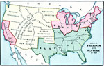
Freedom States and Slavery States,
1854
A map of the United States at the time of the Kansas–Nebraska Act (1854) which allowed settlers to determine whether or not slavery would be allowed in their territories. The map is color–coded to show the Free States (including Californi...
|
|
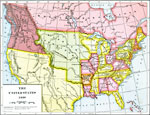
The United States ,
1860
A map of the United States in 1860 showing the states and territory boundaries at the time, and is color–coded to show the slave States and distribution of slaves, the free states, and the territories, all open to slavery under the Compromise o...
|
|
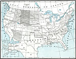
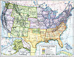
Post Civil War United States,
1865–1892
A map of the United States after the American Civil War showing political facts, boundaries, and conflicts regarding the post-Civil War reconstruction (1865–1892)....
|
|
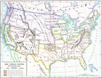
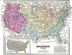
Climate and Watersheds of the United States,
1868
A map from 1868 of the United States showing physical features, mean annual temperatures, rainfall distribution, watersheds, and principal products in the area. The average annual temperatures are shown by isotherms, with temperatures given in degree...
|
|
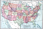
The United States,
1870
A map from 1870 of the continental United States showing state boundaries at the time (eastern Oklahoma was still Indian Territory). The map shows state capitals and major cities, mountain systems, lakes, rivers, and coastal features....
|
|
Reconstructed United States,
1870
A map of the United States and territories after the Civil War during reconstruction and readmission by 1870. The map is color–coded to show the ‘Normal States’ (Union States), the ‘Reconstructed States&’ (Confederate S...
|
Maps ETC is a part of the Educational Technology Clearinghouse
Produced by the Florida Center for Instructional Technology © 2009
College of Education, University of South Florida