| Maps > United States > Early America 1400–1800 |
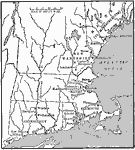 |
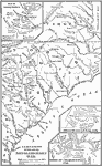
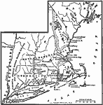
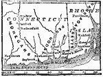
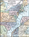
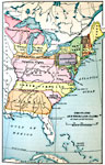
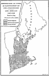
The New England Colonies, 1600s Map showing the New England Colonies. |
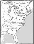 |
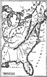
The Location of the Eastern Indian Tribes, 1600s Map showing the location of the Eastern Indian tribes. |
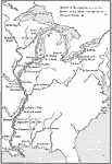 |
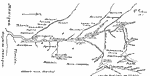
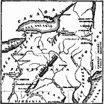
French Explorations and Forts, 1600s Map showing routes taken by French explorers in the Mississippi River area. |
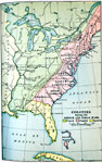 |
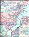
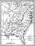
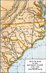
Colonies during the French and Indian Wars, 1754-1763 Map showing various claims to United States land, east of the Mississippi River. |
 |
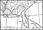
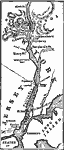
Mississippi Valley, 1672-1673 AD Early map of the Mississippi Valley area of North America. |
 |
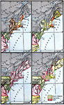
The Colonies and the Revolutionary War, Three section maps to illustrate The Routes of the British Army in the Revolutionary War. |
 |
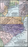
The Routes of the British Army in the Revolutionary War, Three section maps to illustrate The Routes of the British Army in the Revolutionary War. |
 |
Campaigns in the North - The Revolutionary War, Maps to illustrate campaigns in the North during the Revolutionary War. |
 |
Campaigns in the South - The Revolutionary War, Maps to illustrate campaigns in the South during the Revolutionary War. |
 |
New Sweden and New Netherland, Colonial America A map of New Sweden and New Netherland. |
 |
New England Colonies, 1700s A map showing government in the New England colonies. |
 |
New Sweden, 1623 A map showing the planting of New Sweden, and its conquest by the Dutch. |
 |
The United States at the Close of the Revolution, 1783 A map showing the territory of the United States at the close of the Revolution. |
 |
The Route of DeSoto, 1500's Map of the route of DeSoto. |
 |
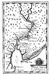
The Coast of Virginia, 1500's Map of the coast of Virginia. |
 |
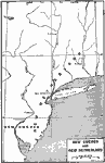
The Chief Settlements made in New England, Between 1620 and 1675 Map of the Chief Settlements made in New England between 1620 and 1675. |
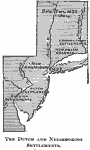 |
The Dutch and neighboring settlements, 1600's Map of The Dutch and neighboring settlements. |
 |
The First Settlements of Pennsylvania and New Jersey, 1600's Map of the first settlements of Pennsylvania and New Jersey. |
 |
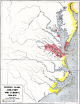
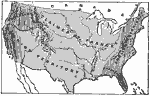
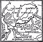
Pioneer Settlements on the Western Frontier, 1700's Map showing Pioneer Settlements on the Western Frontier. |
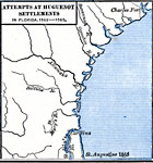 |
Attempts at Huguenot Settlements in Florida, 1562 - 1565 Map shows Attempts at Huguenot Settlements in Florida, 1562-1565. |
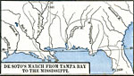 |
DeSoto's March from Tampa Bay to the Mississippi, 1539 - 1541 Map shows DeSoto's March from Tampa Bay to the Mississippi. |
 |
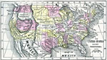
Routes of Spanish Explorers, 1513-1565 A map showing the routes of Spanish explorers in the Southeastern United States. |
 |
The Middle Colonies, 1527 Map showing the Middle Colonies. |
 |
Early Carolina, 1565-1733 AD A map of Carolina, as granted by Charles II. |
 |
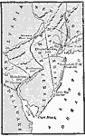
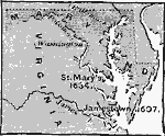
Roanoke Island, Jamestown, and St. Mary's, 1584-1632 A map showing Roanoke Island, Jamestown, and St. Mary's. |
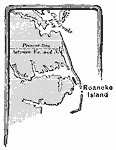 |
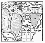
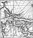
Roanoke Island, 1585 A map of Roanoke Island. |
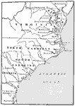 |
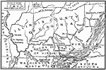
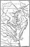
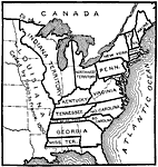
The Southern Colonies, 1606 AD Map showing the Southern Colonies. |
 |
Crown Grants To Trading Companies, 1607 A map showing the crown grants to English trading companies. |
 |
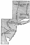
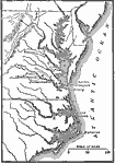
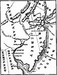
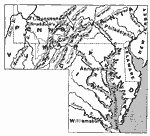
Chesapeake Bay Colonies, 1607-1729 AD A map of the Chesapeake Bay Colonies. |
 |
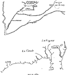
From the Figurative Map, 1616 AD Early map of northeastern coast of North America showing where Native American tribes were living, including the Seneca and Mahican tribes. |
 |
Middle Colonies, 1620 Map of Middle Colonies. |
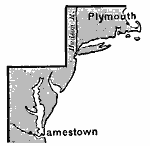 |
Jamestown and Plymouth, 1620 A map showing the colonies of Jamestown and Plymouth. |
 |
New England Colonies, 1620-1636 A map of the New England Colonies. |
 |
Part of De Laet's Map, 1630 AD Early map of northeastern coast of United States showing the Dutch area of New Netherland. |
 |
Maryland and Virginia, 1630-1660 A map showing Maryland and Virginia in the original colonies. |
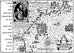 |
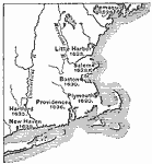
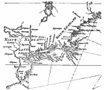
New England, 1631 Maps and plans of notable battles and districts connected with famous authors and their books: This map of New England was produced in 1631 as observed by Captain John Smith in 1614. |
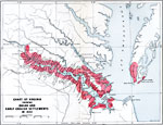 |
Chart of Early Virginia, 1632 A chart of Virginia, showing Native American and early English Settlements. |
 |
Pequod (Pequot) War, 1636-1638 AD A map showing the scene of the Pequod War. |
 |
Map of New Sweden, 1638-1655 Early map of the northeast coast of North America showing New Sweden later to become a part of New Netherland. |
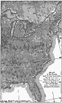 |
Map of the Country East of the Mississippi, 1650 A map of the country east of the Mississippi for the year 1650, forty-seven years after the settlement of Jamestown. |
 |
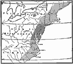
Atlantic Coast Development, 1650-1695 A map showing four periods of Atlantic coast development from 1650 to 1695. |
 |
Visscher's Map, 1651 AD Early map of northeastern coast of United States showing New Sweden including Pennsylvania and Delaware. |
 |
Siege of Christina Fort, 1655 AD Early map of the siege of Fort Christina. The Swedes and the Dutch were in constant battle over this area so the Swedes built Fort Christina and captured the Dutch Fort Casimir. Though, in 1655, New Sweden fell to the Dutch and became part of New Netherland. Fort Christina was renamed Fort Altena. |
 |
Lindstrom's Map, 1654-1655 AD Early map of the east coast of United States showing New Sweden and New Netherland. |
 |
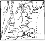
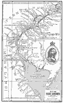
New York and vicinity, 1666 AD Early map of New York and vicinity. |
 |
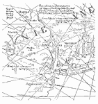
Sir John Lederer's Marches, 1672 Maps and plans of notable battles and districts connected with famous authors and their books: This is the map of the whole territory traversed by John Lederer in his three marches. |
 |
King Philip's War, 1675 AD A map showing the first scene of King Phillip's War. |
 |
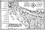
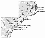
The Carolinas, 1653 to 1680 A map showing the progress of the Carolinas; change of government. |
 |
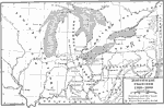
Mississippi Valley, 1682 AD Early map of the Mississippi Valley area of North America. |
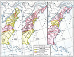 |
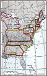
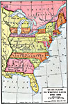
Types of Colonial Governments, 1682-1730 A map showing the types of colonial governments from 1682 to 1730. |
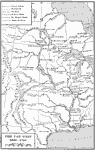 |
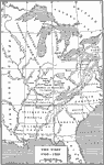
The Far West, 1686-1754 A map of the Far West, from 1686 to 1754. |
 |
Intercolonial Wars, 1689-1713 A map showing the Intercolonial Wars, from 1689 to 1713. |
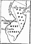 |
The Two Jerseys, 1681 - 1702 A map showing the two Jerseys united. |
 |
Georgia Projected, 1732 A map showing the Carolinas, and part of Georgia. This shows the projection of Georgia and the expansion of the colonies in the south. |
 |
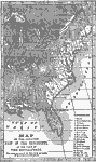
The Present Territory of the United States as claimed by the French, English, and Spanish, 1749 Map of the Present Territory of the United States as claimed by the French, English, and Spanish in 1749. |
 |
The Disputed Territory, 1749 Map of the Disputed Territory of the United States. |
 |
English, French, and Spanish Occupation, 1750 Map of English, French, and Spanish Occupation in United States in 1750. |
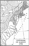 |
Designation of Members to the General Congress of Albany, 1754 A map showing the designation of members to the general Congress of Albany in 1754. |
 |
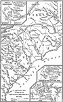
Chief Scene of Operations - French and Indian War, 1754-1755 AD Map of the chief scene of operations of the French-Indian War. |
 |
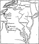
Braddock's March, 1755 A map showing Braddock's March from Fort Cumberland on the Potomac, toward Fort Duquesne. |
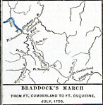 |
Braddock's March from Ft. Cumberland to Ft. Duquesne, July 1755 Map shows Braddock's March from Ft. Cumberland to Ft. Duquesne, July, 1755. |
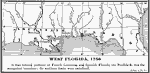 |
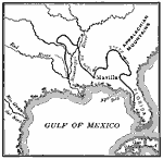
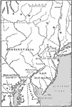
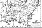
West Florida, 1756 West Florida then formed portions of French Louisiana and Spanish Florida; the Perdido river was the recognized boundary: the northern limits were undefined. |
 |
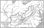
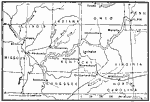
The Western Frontier, 1763 A map showing the western frontier in 1763. |
 |
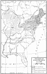
Native American Delimitations, 1763-1770 A map showing Native American delimitations made by treaties, 1763-1770. |
 |
Proposed Western Colonies, 1763-1775 A map showing proposed western colonies from 1763-1775. |
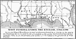 |
West Florida Under the English, 1763-1780 In 1763, the King of Great Britain by royal proclamation limited West Florida on the west by the Mississippi R., on the north by the 31st parallel, on the east by the Chattahoochee and Apalachicola rivers. |
 |
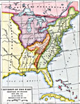
British Possessions in North America, 1765 A map showing British possessions in North America in 1765, as defined by the Treaty of 1763, Proclamation of 1763 and Royal Orders of 1764-1767. |
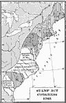 |
Designation of Members to the General Stamp Act Congress, 1765 A map showing the designation of members to the general Stamp Act Congress in 1765. |
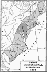 |
First Continental Congress, 1774 A map showing the designation of members to the First Continental Congress in 1774. |
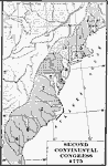 |
Second Continental Congress, 1775 A map showing the designation of members to the Second Continental Congress. |
 |
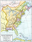
British Possessions in North America, 1775 A map showing the British possessions in North America in 1775, before the outbreak of hostilities. |
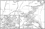 |
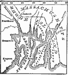
Eastern Massachusetts, 1775 A map showing eastern Massachusetts, with an inset map of Boston and vicinity. |
 |
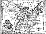
A Map of the Indian Nations, 1775 Maps and plans of notable battles and districts connected with famous authors and their books: This map illustrates the Indian Nations adjoing to the Mississippi, West and East Florida, Georgia, South and North Carolina and Virginia. |
 |
Campaigns in New York and New Jersey, 1775-1776 Map showing the campaigns in New York and New Jersey. |
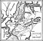 |
Battle of Long Island, 1775-1776 Map showing location of the Battle of Long Island. |
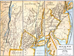 |
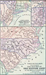
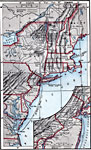
Seat of the War in the Eastern and Middle States, 1775-1780 A group of three maps showing the seat of war in the eastern and middle states, from 1775 to 1780. |
 |
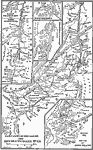
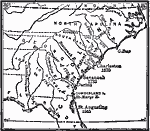
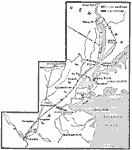
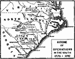
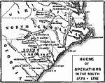
Seat of War in the Southern States, 1775-1781 A map showing the seat of war in the southern states during the American Revolution. |
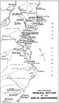 |
Principal Battles of the War of Independence, 1775 to 1781 Maps and plans of notable battles and districts connected with famous authors and their books: This map illustrated the principal battles fought during the American Revolutionary War and their dates. |
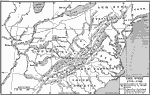 |
The West, 1775-1782 A map of the American West from 1775 to 1785. |
 |
New Settlements and Proposed Communities in the West, 1775-1782 A map showing new settlements and proposed communities in the West, from 1775 to 1782. |
 |
The Colonies and the Revolutionary War, 1775-1783 A map to illustrate the colonies and the Revolutionary War. |
 |
Routes of the British Army, 1775-1783 Three section maps to illustrate the routes of the British Army in the Revolutionary War. |
 |
Campaigns in the North, 1775-1783 A map showing various campaigns in the north during the Revolutionary War. |
 |
Campaigns in the North, 1775-1783 A map of the northern campaigns of the Revolutionary War. |
 |
The Colonies During the American Revolution, 1775-1783 A map illustrating the Revolutionary War. |
 |
The United States, 1776 Map of the United States and their Territories. |
 |
Accessions to the Principal of Independence, 1776 A map showing the accessions to the principal of independence before July 2. |
 |
A Map of the American Indian Nations, 1776 This map shows the records of Native American tribes throughout the South. |
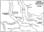 |
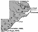
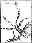
Seige of Charleston, 1776 This is a battle plan of notable battles and districts connected with famous authors and their books: This is a map of the American Revolutionary Siege of Charleston. |
 |
The First Battlegrounds of the Revolution, 1776 Map of the First Battlegrounds of the Revolution. |
 |
The Revolution in the Middle States, 1776 Map of the Revolution in the Middle States. |
 |
The Campaigns in the Middle States, 1777 Map showing the campaigns in the Middle States. |
 |
Seat of War in New Jersey, 1777 Map showing seat of war in New Jersey. |
 |
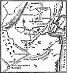
Philadelphia and vicinity, 1777 Map showing Philadelphia and vicinity in 1777. |
 |
Burgoyne's Campaign, 1777 Map showing General Burgoyne's Campaign in 1777. |
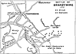 |
Battle of Brandywine, 1777 This is a battle plan of notable battles and districts connected with famous authors and their books: This is a map of the American Revolutionary Battle of Brandywine which led the British to capture Philadelphia. |
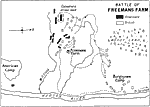 |
Battle of Freemans Farm, 1777 This is a battle plan of notable battles and districts connected with famous authors and their books: This is a map of the American Revolutionary Battle of Freeman's Farm. This battle was the first in the Saratoga campaign and is sometimes known as 'First Saratoga'. |
 |
Routes of Burgoyne and St. Leger, 1777 AD A map showing the routes of Burgoyne and St. Leger, 1777. |
 |
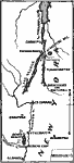
Howe's Route to Philadelphia, 1777 AD A map showing Howe's route to Philadelphia, 1777. |
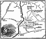 |
Battle at the Brandywine, 1777 A map detailing the Battle of Brandywine during the American Revolution. |
 |
Route of Clark, 1777-1779 A map showing the route of Clark. |
 |
Progress of Emancipation, 1777-1804 A map showing the progress of Emancipation from 1777 to 1804. |
 |
Estimated Degree of Severity of Legislation Against the Loyalists, 1778 A map showing the estimated degree of severity of legislation against the Loyalists. |
 |
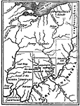
Clark's Campaign in the Northwest, 1778-1779 Map showing Colonel George Rogers Clark's Campaign in the Northwest, 1778-1779. |
 |
The Campaigns in the South, 1778-1779 Map showing the Campaigns in the South. |
 |
The Hudson - Newburg to New York, 1779 Map showing the Hudson River, from Newburg to New York. |
 |
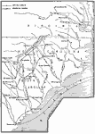
Scene of Operations in the South, 1779-1781 Map showing Scene of Operations in the South from 1779-1781. |
 |
Scene of Operations in the South, 1779-1781 Map showing Scene of Operations in the South from 1779-1781. |
 |
Charleston and vicinity, 1780 Map showing Charleston and vicinity in 1780. |
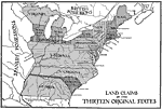 |
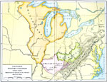
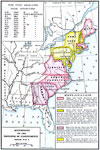
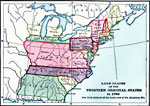
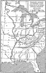
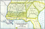
Land Claims of the Thirteen Original States, 1780 This is a regional map of the United States showing the land claims of the original thirteen states during the Revolutionary era. It shows the boundaries of the British and Spanish possessions and the thirteen states and their claimed areas. |
 |
The Hudson, 1780 A map showing the Revolutionary posts in the highlands of the Hudson and the lower part of that river. |
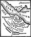 |
Siege of Yorktown, 1781 Map showing Siege of Yorktown. |
 |
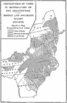
Greene's Campaign in the South, 1781 A map showing Greene's campaign in the southern region of the colonies. |
 |
Division of the West, 1782 A map showing the division of the West proposed by France, on September 6th, 1782. |
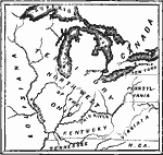 |
Map of the Northwest Territory, 1782-1783 Map of the Northwest Territory in 1782-1783. |
 |
Land Claims of the Colonies, 1783 Land Claims of the Thirteen Original States in 1783. New York claimed all the lands west of the Alleghany mountains. |
 |
The States and their Land Claims at close of Revolution, 1783 Map showing the States and their land claims at close of the American Revolution. |
 |
United States at the Close of the Revolution, 1783 A map of the United States at the close of the Revolutionary War. |
 |
The West, 1783-1789 A map of the American West, from 1783 to 1789. |
 |
State Claims to Western Lands, 1783-1802 A map showing the state claims to Western lands, 1783 to 1802. |
 |
Proposed Division of Western Lands, 1784 A map showing the proposed division of western lands ceded or to be ceded according to the Ordinance of April 23, 1784. |
 |
Division of States, Ordinance of 1784, 1784 The Ordinance of 1784 called for all land between the Mississippi River and the Appalachian Mountains and north of the Ohio River to be separated into ten states. The next year, the Land Ordinance of 1785 was passed in order to clearly define how the land was to be divided. |
 |
Barlow's Map, 1785 "Éshowing the essential parts of a map issued by Barlow in Paris, with his proposals to induce immigration, but the legends are turned into English from the original French. 'This map,Ó says Howe, 'is inaccurate in its geography and fraudulent in its statements.' The country was a wilderness where the map calls it inhabited and cleared, 'habité et défrich&eaccute;.' This region corresponds to what was known as the Seven Ranges of Townships, which Congress, May 20, 1785, directed to be sold, under surveys by Thomas Hutchins; and this is the only foundation for the alleged settlement of them. " (— Winsor, 1888) |
 |
Distribution of Votes in Ratification of the Constitution, 1787-1788 A map showing the distribution of votes in ratification of the constitution in the middle and southern states. |
 |
Distribution of Votes in Ratification of the Constitution, 1787-1790 A map showing the distribution of votes in the ratification of the Constitution in New England. |
 |
Map of the United States at the Close of the Revolution, 1789 The white portions show the extent of settlement at this period. |
 |
Northwest Frontier, 1789-1800 A map showing the Northwest frontier from 1789 to 1800. |
 |
Georgia Claims and Spanish Boundary, 1789-1802 A map showing Georgia claims and the boundary with Spanish Florida. |
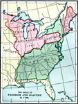 |
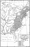
Freedom and Slavery, 1790 A map showing the areas of freedom and slavery in the United States, as of 1790. |
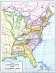 |
The United States, 1790 A map showing the United States in 1790. |
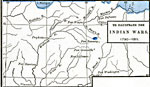 |
To Illustrate the Indian Wars, 1790-1811 One of four maps (on bottom half of this page) illustrating our Indian Wars. |
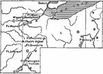 |
Campaign in the Northwest, 1794 A map showing Wayne's campaign against the Indians. |
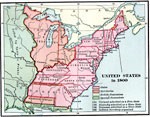 |
United States, 1800 A map showing Free and Slave states in the United States as it was in 1800. 1791 Vermont was admitted as a Free state, 1792 Kentucky admitted as a Slave state, 1796 Tennessee admitted as a Slave state, and 1800 the Indian Territory was organized. |
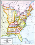 |
The United States, 1800 A map of the United States in 1800. |
 |
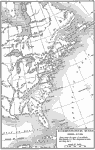
United States, 1800 This map shows the formation of states up until 1800. It reveals the major political boundaries prior to the Louisiana Purchase. "The first new state admitted was Vermont, in 1791, and the last were New Mexico and Arizona, which came into the Union in 1912. At the organization of the government, the Mississippi River formed the western boundary of the United States, and the area of the country was 828,000 square miles." — Foster, 1921 |
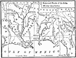 |
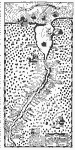
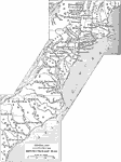
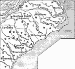
Route of De Soto, 1539 - 1542 Small map of the route De Soto took thru the South East. |
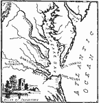 |
Jamestown and Vicinity, 1894 Small map of the Virginia area where early American settlers lived.. |
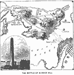 |
The Battle of Bunker Hill, June 17, 1775 Small map of New England area where the Battle of Bunker Hill was fought. |
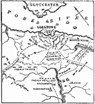 |
Map of the Siege of Yorktown, 1781 Small map of colonial Virginia area where the Siege of Yorktown took place. |
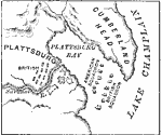 |
Plan of the Battle of Lake Champlain, 1776 Small map of colonial New York area where the Battle of Lake Champlain took place. |
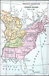 |
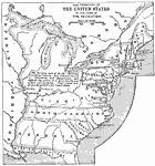
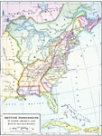
Original Territory of the United States, 1783 This is a map showing the original territory of the United States after the Treaty of Paris 1783. |
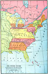 |
The United States at the Close of the Revolution, Showing Land Claims of States, 1911 This is a map showing the United States at the close of the Revolution and western land claims of the states. |
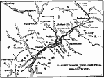 |
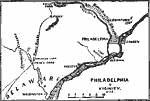
Valley Forge, Philadelphia, and Brandywine, 1911 This is a map showing the location of Valley Forge, Philadelphia and Brandywine where major Revolutionary War battles took place. |
| Maps > United States > Early America 1400–1800 |
Maps is a part of the Educational Technology Clearinghouse
Produced by the Florida Center for Instructional Technology © 2007
College of Education, University of South Florida