Maps Site map
  Maps > United States > Growth of Nation
Site Map  

  Record   1   to   10  of   120

A collection of historic maps of territorial acquisitions and growth of the United States for use in the K-12 classroom.

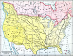
Territorial Growth , 1776–1854
A map from 1890 of the United States showing the territorial expansion from the original Thirteen Colonies in 1776 to the territories prior to the Kansas–Nebraska Act of 1856. The map shows the territories, territorial disputes, and boundary di...

The Growth of the United States, 1776–1867
A map of the United States showing the growth of the nation from 1776–1867. The map is color–coded to show the thirteen original states, the territory acquired by conquest during the revolution and the Treaty of 1783, the Louisiana Territ...

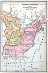
Original Territory of the United States, 1783–1790
A map of the United States showing the territorial growth from 1783 to 1790. The map is color–coded to show the original territory after the American Revolutionary War, the Northwest Territory north of the Ohio River in 1787, the territory sout...

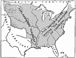
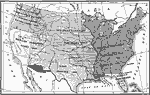
The Territory of the United States before and after the Louisiana Purchase, 1783–1803
A map of the United States showing the extent of the country prior to, and after the Louisiana Purchase from France in 1803....

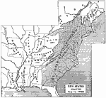
New States Admitted, 1783–1821
A map of the United States showing the original states at the end of the American Revolutionary War (1783) and the states admitted to the Union up to 1821, with the date of admission for each new state given....

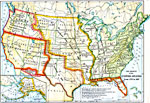
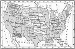
U.S. Territorial Acquisitions, 1783–1853
A map from 1910 of the United States showing the territorial acquisitions from the original states and territory established in 1783 to the Gadsden Purchase in northern Mexico in 1853. This map shows the territories acquired under the Louisiana Purch...

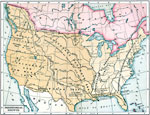
Expansion of the United States , 1783–1853
A map from 1904 of the United States showing the territorial acquisitions up to the Gadsden Purchase in northern Mexico in 1853. The map is coded to show the territory of the original United States and the Northwest Territory defined by the Treaty of...

The Territorial Growth of the United States , 1783–1853
A map from 1894 of the United States showing the territorial growth from the original States and the Northwest Territory in 1783 to the Russian cession of Alaska in 1867. The map is color–coded to show the progression from the original thirteen...

Territorial Growth of the United States, 1783–1853
A map from 1907 of the United States showing the growth of the nation from 1776–1853. This map is coded to show the thirteen original states, and the territories acquired in 1783, by the Louisiana Purchase in 1803, the northern territories, Wes...

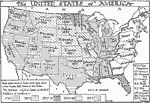
The United States of America, 1783–1853
A map of the United States showing the growth of the nation from 1776–1853. This map is coded to show the thirteen original states, and the territories acquired in 1783, by the Louisiana Purchase in 1803, the northern territories, West Florida,...

Next Last


  Maps > United States > Growth of Nation
Site Map  

Maps ETC is a part of the Educational Technology Clearinghouse
Produced by the Florida Center for Instructional Technology © 2009
College of Education, University of South Florida