Maps Site map
  Maps > United States > Maryland
Site Map  

  Record   1   to   10  of   12

A collection of historic and contemporary political and physical maps of Maryland, including early exploration and settlement maps, and city plans, for use in the K-12 classroom.

Oceanus Orientalis (Maryland), 1635
A facsimile of an early map of Maryland and the Chesapeake Bay (1635)....

Vicinity of Baltimore, 1814
A map from 1872 of the vicinity of Baltimore in 1814, showing the battle sites and fortifications during the British campaign to capture the city....

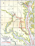
Chesapeake Campaign, 1814
A map of the Chesapeake Campaign (1814) of the War of 1812 showing the routes of British advance and retreat on the capture of the city of Washington and Battle of Baltimore, the routes of the American forces, American fortifications, and battle site...

Vicinity of Baltimore, 1814
A sketch map of the vicinity of Baltimore during the War of 1812 showing British movements after the burning of Washington in August, 1814. The map shows the Patapsco River and Chesapeake Bay, the British fleet position in the bay, the landing site o...

Battle of Antietam, 1862
A map of the vicinity of Sharpsburg, Maryland, site of the Battle of Antietam during the American Civil War (September 17, 1862). The map shows Union and Confederate troop positions over the course of the battle, Antietam Creek, and artillery positio...

Vicinity of Annapolis, 1872
A map from 1872 of the vicinity of Annapolis (formerly called Providence), now the capital of Maryland, situated on the southwest side of the river Severa, two miles from its entrance into Chesapeake Bay. It is twenty five miles south from Baltimore,...

Maryland, 1902
A map from 1902 of Maryland showing the capital Annapolis, major cities, towns, and ports, railroads, rivers, and coastline features of the Chesapeake Bay. An inset map details the city of Washington....

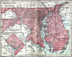
Maryland and Delaware, 1906
A map from 1906 of Maryland and Delaware showing the capitals of Annapolis and Dover, major cities, towns, and ports, railroads, rivers, and coastline features of the Chesapeake Bay, Delaware Bay, and Atlantic. Inset maps detail the city of Washingto...

Swampy Divides in Maryland, 1911
A contour map of eastern Maryland showing the landform features of the swampy divides between the Chesapeake and the Atlantic. The coastal plain is here so young and so little dissected that many of the original irregularities have not yet been destr...

Baltimore, Maryland, 1914
A city plan from 1922 of Baltimore showing major streets, railroads and stations, harbor and basin, the Patapsco River, parks, and major landmarks. An inset map details the business section of the city....

Next Last


  Maps > United States > Maryland
Site Map  

Maps ETC is a part of the Educational Technology Clearinghouse
Produced by the Florida Center for Instructional Technology © 2009
College of Education, University of South Florida