Below are several options for U.S. regional maps from the Maps ETC collection. Regional maps are maps which extend beyond the border of a single state, encompassing a major area of the United States. Browse the locater maps to find the regional area that is needed, and click the image or given link for historical and contemporary maps of that region. If you do not find a specific region you are looking for, you can check the United States Regional Maps, Misc. page, which contains combinations of several regions.
|
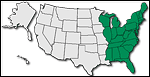
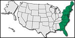
Eastern States
A collection of historic and contemporary maps of the eastern United States, and includes all states east of the Mississippi River.
|
|
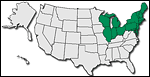
Northeast States
A collection of historic and contemporary maps of northeastern United States, which is the region East of Mississippi River and North of Ohio and Potomac Rivers. This includes Connecticut, Delaware, District of Columbia, Illinois, Indiana, Maine, Maryland, Massachusetts, Michigan, New Hampshire, New Jersey, New York, Ohio, Pennsylvania, Rhode Island, Vermont, and Wisconsin.
|
|
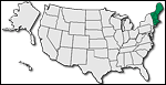
New England States
A collection of historic and contemporary maps of the New England region of the United States, and includes Connecticut, Maine, Massachusetts, New Hampshire, Rhode Island, and Vermont.
|
|
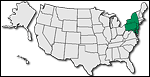
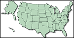
Middle Atlantic States
A collection of historic and contemporary maps of the Mid-Atlantic region of the United States, and includes Delaware, District of Columbia, Maryland, New Jersey, New York, and Pennsylvania.
|
|
Atlantic States
A collection of historic and contemporary maps of the Atlantic Region of the United States. This includes all states from Maine to Florida that are near to or border on Atlantic Ocean.
|
|
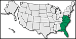
South Atlantic States
A collection of historic and contemporary maps of the South Atlantic region of the United States, and includes Florida, Georgia, North Carolina, South Carolina, and Virginia.
|
|
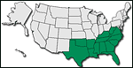
Southern States
A collection of historic and contemporary maps of the Southern Region of the United States, and includes all states South of Mason-Dixon Line and Ohio River, from the western Texas border to the Atlantic Ocean. This includes Alabama, Arkansas, Florida, Georgia, Kentucky, Louisiana, Mississippi, North Carolina, Oklahoma, South Carolina, Tennessee, Texas, Virginia, and West Virginia.
|
|
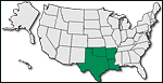
Old Southwestern States
A collection of historic and contemporary maps of the Old Southwest region of the United States, which was the Southwestern US before cessions of land from Mexico following Mexican War, and includes the states of Arkansas, Louisiana, Oklahoma, and Texas.
|
|
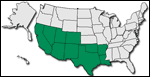
Southwestern States
A collection of historic and contemporary maps of the Southwestern United States, and includes Southern States West of Mississippi River. This includes Arkansas, Arizona, California, Colorado, Louisiana, Nevada, New Mexico, Oklahoma, Texas, and Utah.
|
|
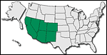
New Southwestern States
A collection of historic and contemporary maps of the New Southwestern region of the United States, which corresponds to old Spanish province of New Mexico, and includes Arizona, California, Colorado, Nevada, New Mexico, and Utah.
|
|
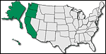
Pacific States
A collection of historic and contemporary maps of the Pacific Region of the United States, and includes states that border the Pacific Ocean: Alaska, California, Hawaii, Oregon, and Washington.
|
|
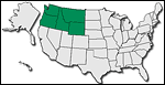
Pacific Northwest States
A collection of historic and contemporary maps of the Pacific Northwest region of the United States, and includes the Old Oregon country: Idaho, Oregon, Montana, Washington, and Wyoming.
|
|
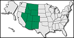
Rocky Mountain States
A collection of historic and contemporary maps of the Rocky Mountain region of the United States, and includes Arizona, Colorado, Idaho, Montana, Nevada, New Mexico, Utah, and Wyoming.
|
|
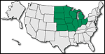
Midwest States
A collection of historic and contemporary maps of the Midwest region of the United States, and includes states from the Rocky Mountains to Allegheny Mountains, North of Ohio River and southern border of Missouri and Kansas: Illinois, Iowa, Indiana, Kansas, Michigan, Minnesota, Missouri, Nebraska, North Dakota, Ohio, South Dakota, and Wisconsin.
|
|
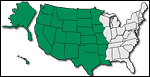
Western States
A collection of historic and contemporary maps of the Western United States, and includes all states west of the Mississippi River.
|
|
Miscellaneous United States
A collection of historic and contemporary maps of other regions of the United States.
|