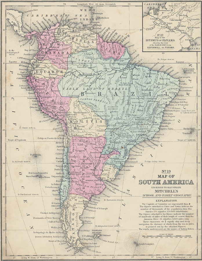
Description: A map of South America from 1863 showing the national boundaries of the time including New Granada, Venezuela, Guiana (British, Dutch, and French), Equador (Ecuador), Peru, Brazil, Bolivia, Chile, Argentine Confederation, Uruguay, and Patagonia. Major cities, ports, railroads, rivers, lakes, mountain systems, and terrain coastal features are shown. An inset map details the Isthmus of Panama before construction of the canal, showing the railroad route between Aspinwall on the Caribbean and Panama City on the Pacific. Longitude is shown from Greenwich at the top of the map, and from Washington at the bottom. The map notes nautical distances between South America and the Gallapagos (Galapagos) Islands, Tahiti, Australia, New Zealand, Cape Colony, and Pongo (West Africa), the point where land was first seen by Pedro Cabral, the Island of Fernando de Noronha (penal colony), and the gold and diamond districts of Brazil. The Capitals of Countries are represented with a dot with a ring of dots around it. The figures attached to Cities and Towns indicate the number of thousands of the population, thus Rio Janeiro 170 signifies 170,000 inhabitants. The figures attached to the Rivers indicate the number of hundreds of miles of their length of course, thus the Amazon River 36, signifies 3,600 miles long. Anchor symbols signify ship and sloop navigation, the distance of which from the sea in miles is pointed out by the attached figures. The words underscored are the names of Indian Tribes.
Place Names: A Complete Map of South America, Argentina, �Bolivia, �Brazil, �Chile, �Ecuador, �Paraguay, �Peru, �Uraguay, �Venezuela, �Chili, Equador, Granada, Guiana, Uruguay, Patagoni
ISO Topic Categories: boundaries,
inlandWaters,
location,
oceans
Keywords: Map of South America, physical, �political, physical features, country borders, boundaries,
inlandWaters,
location,
oceans, Unknown, 1858
Source: , Mitchell's School Atlas (Philadelphia, Pennsylvania: E. H. Butler & Co., 1863)
Map Credit: Courtesy the private collection of Roy Winkelman |
|