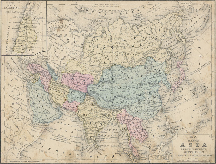
Description: A map from 1858 of Asia showing the political and territorial boundaries at the time, including the Chinese Empire, Russian Empire, Turkestan, Turkey, Georgia, Syria, Arabia, Beloochistan, Afghanistan, Hindoostan, Birmah, Laos, Cambodia, Malacca, and the Empire of Japan. This map shows capital cities and other major cities, trade centers, and ports, including the Free Ports of China and Japan (underlined). The map shows general terrain including mountain systems with the elevations of prominent peaks, deserts, plains, rivers, lakes, coastal features, and islands, with the length in miles of major islands. The figures attached to rivers indicate the number of hundreds of miles of their length of course, thus the Ganges River 16 signifies 1,600 miles long. The map notes the northernmost Arctic point reached by Robert Perry by boat in 1827, locations of several historic ruins, and shows the territories of Muscat (Oman) at the time. The Great Wall and Grand Canal of China are shown. The areas of various ethnic groups are indicated by capital italics. Longitudes from Greenwich are shown at the top of this map, with longitudes from Washington at the bottom. An inset map of Palestine and the Holy Lands shows several historic sites of the area.
Place Names: A Complete Map of Asia, China, �India, �Japan, �Mongolia, �Phillipines, �Russia, �Thailand, �Bokhara, Koondooz, Cashgar, Yarkand, Khoten, Thibet, Lassa, Birmah, Amerapoora, Cochin China, Malacca, Welly, Niphon, Jesso, Osaghalien, Kamtschatika, Mantchooria, Hindoostan, Aracan,
ISO Topic Categories: boundaries,
inlandWaters,
location,
oceans,
transportation,
structure
Keywords: Asia, physical, �political, physical features, country borders,
major political subdivisions, boundaries,
inlandWaters,
location,
oceans,
transportation,
structure, Unknown, 1858
Source: , Mitchell's School Atlas (Philadelphia, PA : E. H. Butler & Co., 1863)
Map Credit: Courtesy the private collection of Roy Winkelman |
|