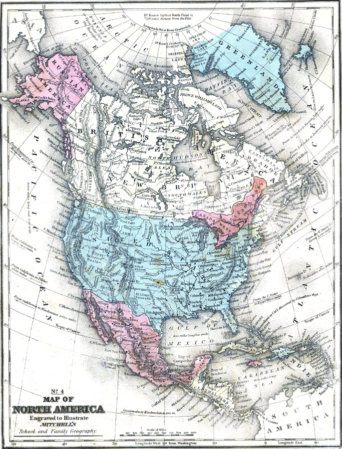
Description: A map from 1858 of North America showing the boundaries at the time for Russian America (Alaska), Greenland, British America or New Britain, Canada East and Canada West, the United States, Mexico, Central America, and the West Indies Islands. The map shows major cities, mountain systems, lakes, rivers, and coastal features. The figures attached to rivers indicate the number of hundreds of miles of their length of course, thus the Mississippi River 41 signifies 4,100 miles long. The words underscored are the names of Indian Tribes. The lengths of major islands are given in miles. Longitude from Greenwich is given at the top of the map, with longitude from Washington at the bottom. Map notes indicate the Polynja, or open polar sea of the Russians, the North–West Passage route of Capitan McClure in 1852, several sailing distances between ports in the Americas and ports in Asia, Europe, and Egypt, the Panama Isthmus as part of northern Granada (Columbia), the landing site of Columbus given as Guanahani or Cat Island, the Gulf Stream, the submarine ocean telegraph cable from Newfoundland to Europe (1,980 miles long), and the route of Dr. Elisha Kane's Arctic Expedition of 1853, showing his winter quarters in northern Greenland, and the farthest north point reached (North 82° 30’), 519 miles distant from the pole.
Place Names: A Complete Map of North America, North America, �Asia, �South America, �Bahamas, �Canada, �Cuba, �Mexico, �United States, �Hayti, Jamaica, Aspinwal
ISO Topic Categories: location,
oceans,
inlandWaters,
elevation,
boundaries,
utilitiesCommunication
Keywords: North America, physical, �historical, �hayti, aspinwall, sir jon franklin june 11 1847, guatimala, physical features,
topographical, country borders, historical event, location,
oceans,
inlandWaters,
elevation,
boundaries,
utilitiesCommunication, Unknown, 1858
Source: , Mitchell's School Atlas (Philadelphia, PA : E. H. Butler & Co., 1863)
Map Credit: Courtesy the private collection of Roy Winkelman |
|