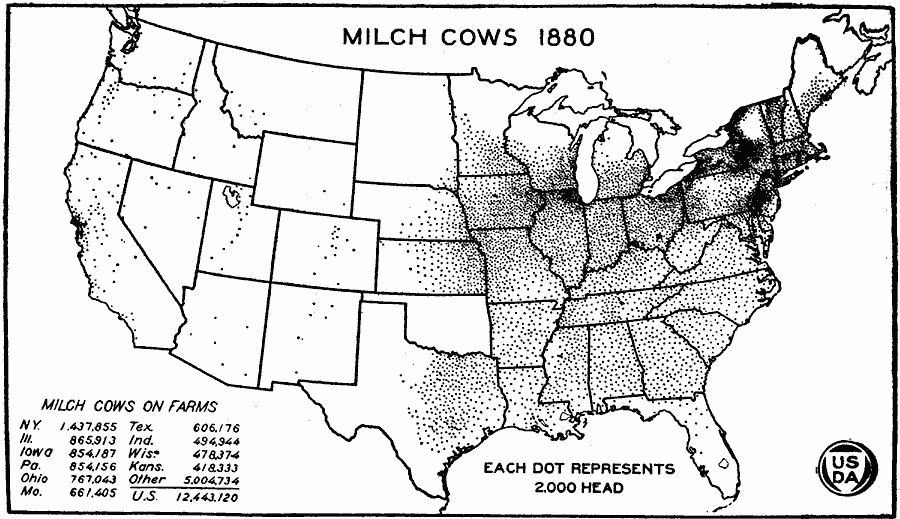
Description: A map of the United States from the U. S. Department of Agriculture (1922) showing the distribution of Milch Cows in the United States in 1880. "Between 1870 and 1880 the number of cows increased nearly 50 per cent. The greatest increases were in Iowa, Kansas, Illinois, Wisconsin, and Minnesota. By 1880 nearly all of the States had recovered from the Civil War depression in number of cows. The westward movement had reached the semi–arid Great Plains." — United States Department of Agriculture Yearbook 1922, 1923.
Place Names: Agriculture, New York, Illinois, Iowa, Pennsylvania, Ohio, Missouri, Texas, Indiana, Wisconsin, Kansas, �cattl
ISO Topic Categories: boundaries,
inlandWaters,
farming
Keywords: Milch Cow Distribution, physical, �political, �statistical, �milch cow distribution, milk cow, dairy cow, kAgriculture, physical features, country borders,
major political subdivisions, agriculture, boundaries,
inlandWaters,
farming, Unknown, 1880
Source: , United States Department of Agriculture Yearbook 1922 (Washington, DC: Government Printing Office, 1923) 299
Map Credit: Courtesy the private collection of Roy Winkelman |
|