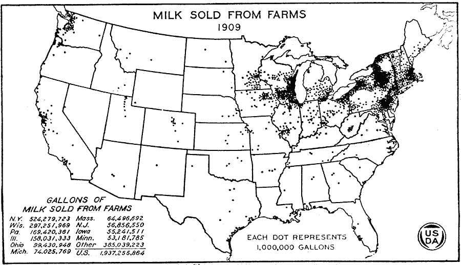
Description: A map of the United States from the U. S. Department of Agriculture (1922) showing the number of gallons of milk sold from farms in 1909 by state. "On this map groups of dots generally locate large cities. In the larger black areas milk is also sold to condensaries, cheese and butter factories. Railroads carried milk to New York City from the Canadian border on the north and from near Buffalo on the west." — United States Department of Agriculture Yearbook 1922, 1923.
Place Names: Agriculture, New York, Wisconsin, Pennsylvania, Illinois, Ohio, Michigan, Massachusetts, New Jersey, Iowa, Minnesota, �dairy product
ISO Topic Categories: boundaries,
inlandWaters,
farming,
economy
Keywords: Milk Sold from Farms, physical, �political, �statistical, �milk sold from farms, milk production in gallons by state, kAgriculture, physical features, country borders,
major political subdivisions, agriculture,
economic, boundaries,
inlandWaters,
farming,
economy, Unknown, 1909
Source: , United States Department of Agriculture Yearbook 1922 (Washington, DC: Government Printing Office, 1923) 304
Map Credit: Courtesy the private collection of Roy Winkelman |
|