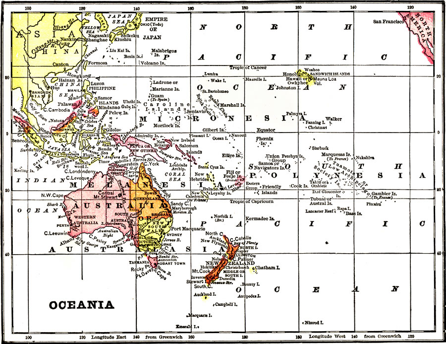
Description: A map from 1904 of Oceania and the Pacific. "Oceanica, sometimes called Oceania, is the name applied to the fifth division of the globe, which comprises the Australian Continent and a majority of the islands lying between the Indian Ocean and the China Sea on the west, and the American Continent on the east. So vast is the number of these islands that only the historical facts relating to the largest of them can be mentioned. Australia comes under its own head. New Guinea was discovered by the Portuguese in 1511. It is now divided between Holland, England and Germany; the German portion is called Kaiser Wilhelm's Land. Borneo, which, until the naturalist Wallace's explorations proved that New Guinea had the greater area, was believed to be the largest island in the world except Australia, was discovered in 1578 by the Portuguese. In 1690 they effected a settlement, but were soon driven out from it. In 1702 and 1774 England made unsuccessful attempts to colonize the island, but of late years she has managed to acquire a controlling influence over the northwestern coast of the island. Sumatra, Java, Celebes are among the larger single islands, while among the most important groups are the Malay Archipelago, in which these are included, and almost all of which have been subjugated by the Dutch, the Spaniards, the Portuguese and the British; the New Hebrides and Polynesia, which general terms include, among others, the Hawaiian, which is one of the most important in the Pacific Ocean. In 1829 the independence of these islands was acknowledged by the United States, who were followed in 1843 by the British, and in 1844 by the French. Queen Liliuokalani succeeded Kalakau, but a revolution breaking out in 1893, the Queen was deposed and a Hawaiian Republic was proclaimed with a new Constitution, July 4, 1894. Sanford B. Dole became its first President. Since then the Hawaiian Senate has passed a resolution favoring annexation to the United States." &mdash Wark, 1904.
Place Names: Regional Pacific Ocean, Australia, �French Polynesia, �Federated States of Micronesia, �Kiribati, �Indonesia, �Melanesia, �Hawaiian Islands, �Marshall Islands, �New Zealand, �Papua New Guinea, �Solomon Island
ISO Topic Categories: physical, �political, kWorldPacific
Keywords: Oceania, physical, �political, physical features,
topographical, country borders, physical, �political, kWorldPacific, Unknown, 1904
Source: Henry Wark, ed. , Wark's Modern Educator (New York, NY: Henry Wark, 1904) 943
Map Credit: Courtesy the private collection of Roy Winkelman |
|