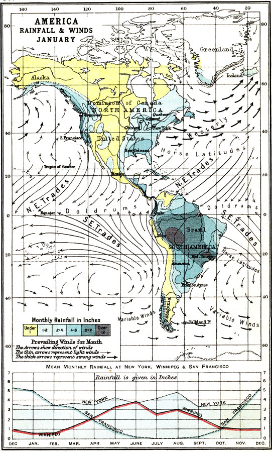
Description: A map of the Americas from 1911 showing typical patterns of rainfall and prevailing winds of the region for the month of January. The map is color–coded to show areas where mean rainfall is less than one inch for the month in yellow, between 1–12 inches in shades of blue, and over 12 inches in purple. The map shows prevailing wind patterns for the month, with arrows indicating wind direction. Thin arrows represent light winds, while thick arrows represent strong winds. The map shows the regions of the North–East and South–East Trade Winds, the Westerlies, the Horse Latitudes, the Equatorial Doldrums, and the southern region of variable winds. A chart at the bottom of the map shows the curve of mean annual rainfall by month for the northern hemisphere cities of New York, Winnipeg, and San Francisco given in inches.
Place Names: Regional Americas, North America, �South Americ
ISO Topic Categories: meteorological, kClimate, kWorldAmericas
Keywords: Rainfall and Prevailing Winds for January in the Americas, meteorological, kClimate, rainfall,
winds, meteorological, kClimate, kWorldAmericas, Unknown, 1911
Source: Ernest Rhys, Ed., A Literary and Historical Atlas of North & South America (New York, NY: E.P. Dutton & CO., 1911) 30
Map Credit: Courtesy the private collection of Roy Winkelman |
|