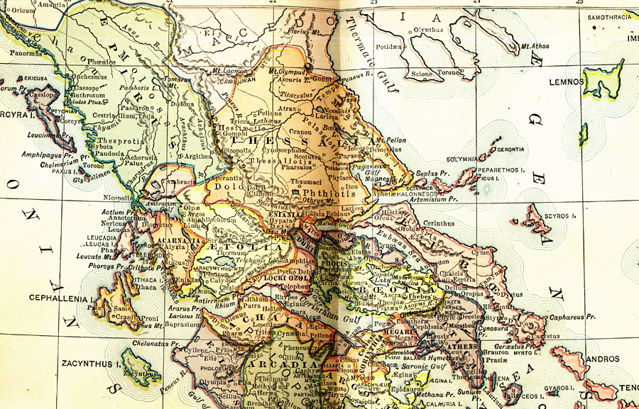
Description: A map of ancient Greece showing districts, cities, and waterways. "Divisions of Greece. — Long arms of the sea divide the Grecian peninsula into three parts, called Northern, Central, and Southern Greece. Northern Greece included the ancient districts of Thessaly and Epirus. Thessaly consists mainly of a large and beautiful valley, walled in on all sides by rugged mountains. It was celebrated far and wide for the variety and beauty of its scenery. On its northern edge, lay a beautiful glen, called the Vale of Tempe, the only pass by which the plain of Thessaly could be entered from the north. The district of Epirus stretched along the Ionian Sea on the west. In the gloomy recesses of its forests of oak was situated the renowned Dodonean oracle of Zeus. Central Greece divided into eleven districts, among which were Phocis, Boeotia, and Attica. In Phocis was the city of Delphi, famous for its oracle and temple; in Boeotia, the city of Thebes; and in Attica, the brilliant Athens. Southern Greece, or the Peloponnesus, was also divided into eleven provinces, of which the more important were Arcadia, embracing the central part of the peninsula; Achaia, the northern part; Argolis, the eastern; and Messenia and Laconia, the southern. The last district was ruled by the city of Sparta, the great rival of Athens." —Myers, 1896
Place Names: Greece, Athens, �Ionian Sea, �Myrtoan Sea, �&Aelig;gean Sea, �Cyclade
ISO Topic Categories: boundaries,
oceans,
inlandWaters
Keywords: General Reference Map of Ancient Greece, physical, �political, �historical, physical features,
topographical, country borders,
major political subdivisions, boundaries,
oceans,
inlandWaters, Unknown, Circa 500 BC
Source: P. V. N. Myers, A General History for Colleges and High Schools (Boston, MA: Ginn & Company, 1896) 88
Map Credit: Courtesy the private collection of Roy Winkelman |
|