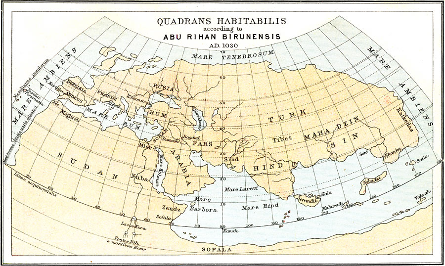
Description: A facsimile from 1912 of the habitable world (Quadrans Habitabilis) according to the Persian scholar and geographer Abu Rihan Birunensis (Abu Rayhan Biruni) in AD 1030. This map shows Europe, Asia, and North Africa as it was known, with the place names of the time, including Dzelikia and Andlus (Iberian Peninsula), Frandz (France), Rusia (Russia), Rum (Asia Minor), Fars (Persia), Scham (Syria and Palestine), Arabia, Turk (northern Asia), Maha Dzin Sind (China and eastern Asia), Hind (India), Sudan (North Africa), and Sofala (non–existent eastern Africa). Cities shown include Kortoba (Córdoba, Spain), Fes (Fez, Morocco), Rumia (Rome), Kostatina (Constantinople), Bagdad, and Damask (Damascus), and the seas Mare Ambiens (both the Atlantic and Pacific, which were thought to be one ocean), Mare Hind (Indian Ocean), and Mare Rum (Mediterranean).
Place Names: A Complete Map of Globes and Multi-continent, Sudan, �Sofala, �Turk, �Hind, �Rusia, �Fars, �Arabi
ISO Topic Categories: society
Keywords: Quadrans Habitabilis according to Abu Rihan Birunensis, historical, �physical, kEarlyMapsFacsimile, physical features, society, Unknown, 1030
Source: Ernest Rhys, Ed., A Literary and Historical Atlas of Asia (New York, NY: E.P. Dutton & CO., 1912) 3
Map Credit: Courtesy the private collection of Roy Winkelman |
|