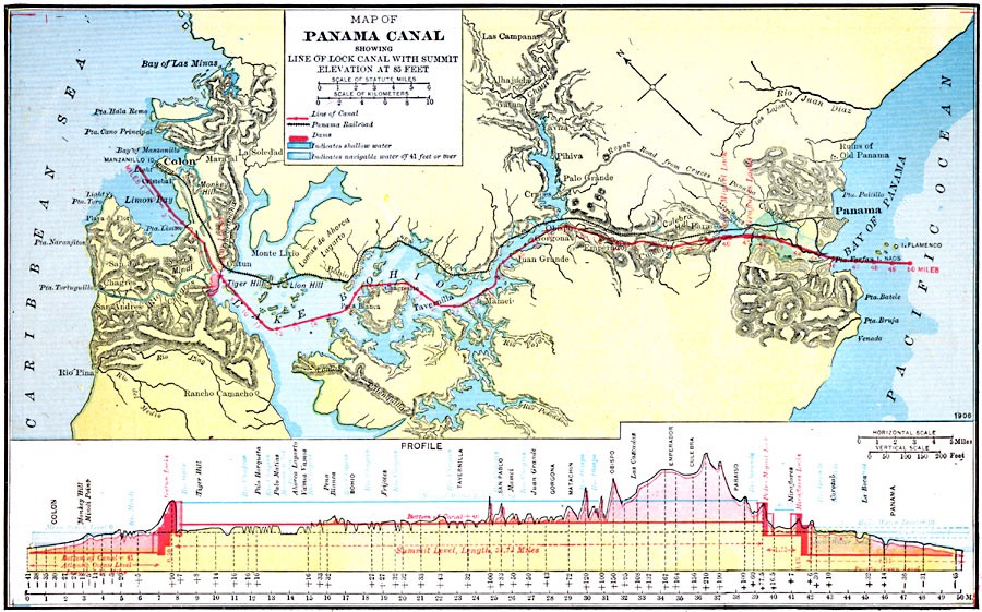
Description: A map from 1920 of the Panama Canal showing the channel route from Colon to the city of Panama with the miles given along the route from Colon, railroad route, lakes, reservoirs, the Gatun dam, locks, and towns along the canal. The map is color–coded to show water depths, with dark blue indicating shallow water, and light blue indicating navigable water of 41 feet or more. A chart at the bottom of the map shows a profile of the isthmus with the canal system of locks and the dam necessary to reach a water–surface elevation of 85 feet to transfer ships from the Atlantic or Pacific.
Place Names: Panama Canal Zone, Colon, �Panam
ISO Topic Categories: boundaries,
inlandWaters,
location,
oceans,
transportation
Keywords: The Panama Canal, physical, �political, physical features, local jurisdictions, water routes,
railroads, boundaries,
inlandWaters,
location,
oceans,
transportation, Unknown, 1920
Source: John C. Winston, Winston's New and Complete Atlas of the World (New York, NY: The John C. Winston Company, 1920) 130
Map Credit: Courtesy the private collection of Roy Winkelman |
|