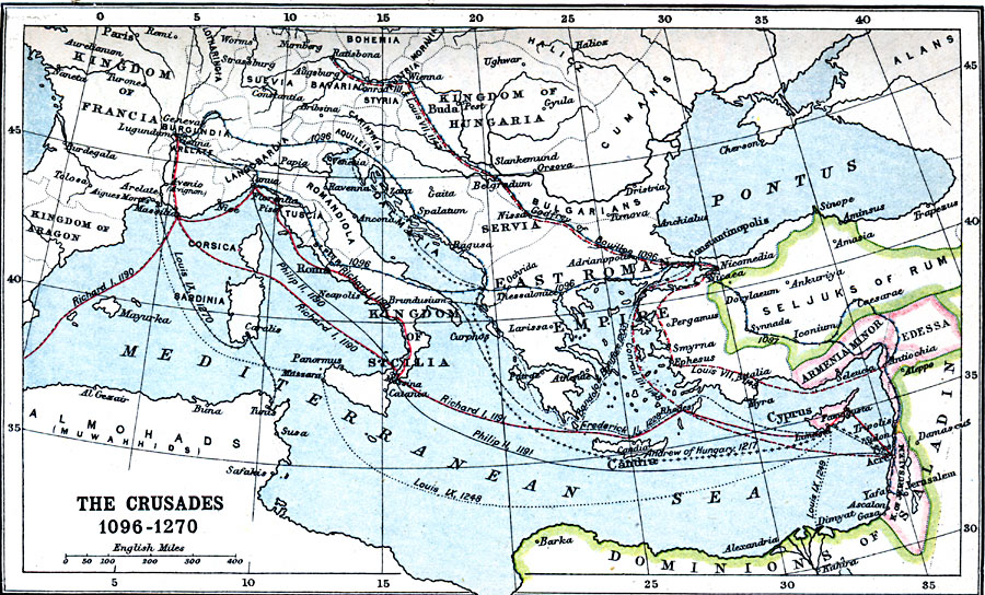
Description: A map of Europe and the Mediterranean Asia Minor region where the Crusades took place from 1096–1270, including the routes of Godfrey of Bouillon, first ruler of the Kingdom of Jerusalem (1096 — First Crusade), to Constantinopolis (Constantinople), and Jerusalem (1097), Conrad III and Louis VII (1147 — Second Crusade) to Jerusalem, Conrad III (1148) return to Jerusalem from Constantinople, Richard I (1190 — Third Crusade), Phillip II (1190 — Third Crusade), Bandofo (Enrico Dandolo) and Boniface I (1203 — Fourth Crusade) to Constantinople during the Great Schism, Andrew of Hungary (1217 — Fifth Crusade), Frederick II (1228 — Sixth Crusade), Louis IX (1248 — Seventh Crusade) to Cyprus, and Egypt (1249), Louis IX (1270 — Eighth Crusade) to Tunis. The map shows European territories at the time, including the Kingdom of Francia, Burgundia, Kingdom of Aragon, Lotharingia, Suevia, Langobardia, Bohemia, Bavaria, Styria, Romandiola, Tuscia, Kingdom of Sicilia, Kingdom of Hungary, Dalmatia, Servia, and the East Roman Empire, the Asia Minor territories of the Seljuks of Rum, Armenia Minor, Edessa, Cyprus, the Kingdom of Jerusalem, and the North African territories of the Dominions of Saladin and the Almohads (Muwahhids). Many of the place names are of the period, such as Pontus (Black Sea), Candia (Crete), Ratisbona (Regensburg), and Lugundum (Lyon).
Place Names: Regional Mediterranean, Bulgaria, �France, �Hungary, �Roman Empire, �Servia,
ISO Topic Categories: country borders, �political, kCrusades, kWorldMedSea, kWorldEurasia, kWorldAfroAsia
Keywords: The Crusades, country borders, �political, kCrusades, country borders, country borders, �political, kCrusades, kWorldMedSea, kWorldEurasia, kWorldAfroAsia, Unknown, 1096–1270
Source: J.G. Bartholomew, LLD, A Literary & Historical Atlas of Europe (New York, NY: E.P. Dutton & Co., Ltd. , 1910) 19
Map Credit: Courtesy the private collection of Roy Winkelman |
|