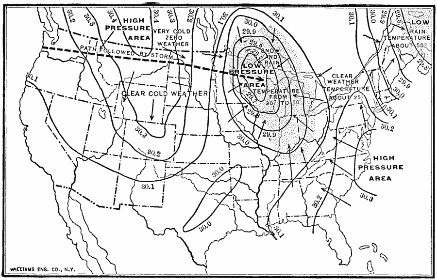
Description: A sample weather map from 1910 of the United States showing typical weather patterns and a winter storm event. The map shows a low pressure system moving from the Northern Plains into the Great Lakes region and in the Northeast, a high pressure system over the northern Rockies and off the Atlantic Coast. The map shows the storm track from west to east (heavy dashed line), prevailing wind directions flying with the arrow symbols from areas of high pressure towards areas of low pressure, lines of equal barometric pressure (isobars) reduced to sea level, cold and very cold clear–weather temperatures from the arid northern regions moving into the low pressure system, and the snow and rainy–weather temperatures averaging from 30 to 50 degrees Fahrenheit.
Place Names: Meteorology, Weathe
ISO Topic Categories: boundaries,
location,
oceans,
inlandWaters,
climatologyMeteorologyAtmosphere
Keywords: Weather Map of the United States, physical, �political, �meteorological, kClimate, physical features, country borders, climate, boundaries,
location,
oceans,
inlandWaters,
climatologyMeteorologyAtmosphere, Unknown, 1910
Source: Ralph S. Tarr, B.S., F.G.S.A. and Frank M. McMurry, Ph.D., New Geographies 2nd ed (New York, NY: The Macmillan Company, 1910) 216
Map Credit: Courtesy the private collection of Roy Winkelman |
|