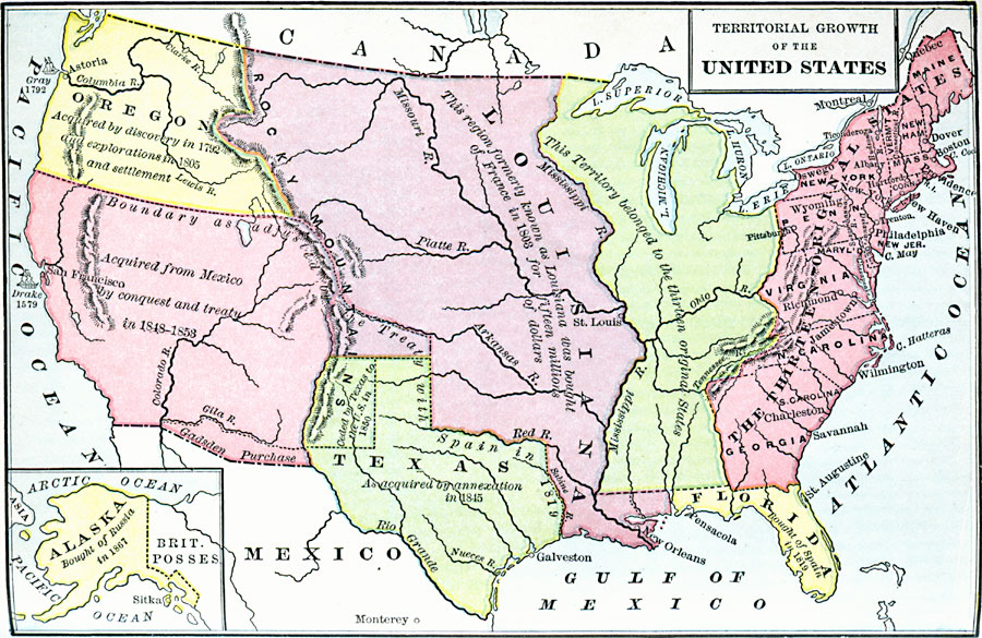
Description: A map from 1897 of the United States showing the territorial growth from the original States and the Northwest Territory in 1783 to the purchase of Alaska from Russia in 1867. The map is color–coded to show the progression from the original thirteen States and Northwest Territory, the purchase of Louisiana from France in 1803, the Oregon Country acquired by discovery and exploration in 1805, purchase of Florida from Spain in 1819, Texas annexation in 1845 and cession in 1850, the first Mexican cession in 1848, second Mexican cession or Gadsden Purchase in 1853, and includes an inset map showing the Alaskan purchase in 1867.
Place Names: Growth of Nation, Alaska, �Florida, �Louisiana, �Mississippi River, �Oregon, �Texas, ��Louisiana Purchase, �Gadsden Purchase, �East Florida, �California, �Mexican Cession, �Oregon Country, �Original Colonies, �Spanish Territory, �West Florid
ISO Topic Categories: oceans,
location,
inlandWaters
Keywords: Territorial Growth of the United States , borders, �historical, oceans,
location,
inlandWaters, Unknown, 1783–1867
Source: Henry Pratt Judson, The Young American A Civic Reader (New York, NY: Maynard Merrill, 1897)
Map Credit: Courtesy the private collection of Roy Winkelman |
|