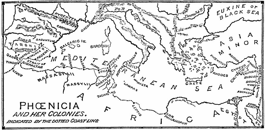
Description: A map of the Mediterranean region around 1200 to 333 BC, showing the settlements, colonies, and coastal claims of the early Phoenicians, from Phoenicia in the eastern Mediterranean to the Strait of Gibraltar and Atlantic coast of Spain and Africa. The map shows the island realms of Cyprus, Malta, Sardinia, and the Balearic Islands, the northern coast of Africa and Tarshish in southern Spain under Phoenician control, and the Phoenician settlements of Chittim on Cyprus, Philænopum, Leptis, Tacape, Carthage, Utica, Hippo Zarytus, Hippo (Hippo Regius), Saldae, Icosium, Iol, Tingis, and Lixus in North Africa, Gades (Cadiz), Carteia, Malaca, Abdera, Saguntum, and Carthago in Spain, Caccabara (Massilia or Marseille) in France, Motye and Solus on Sicily, Phoenicus and Agidus in Asia Minor, and the Phoenician cities of Aradus, Tripolis, Byblus, Sidon, Tyre, Joppa, and Aycalon.
Place Names: Miscellaneous Asia, Phoenici
ISO Topic Categories: boundaries,
oceans,
location,
inlandWaters
Keywords: Phoenicia, physical, �political, physical features, major political subdivisions, boundaries,
oceans,
location,
inlandWaters, Ancient Phoenicia
Source: William Swinton, Outlines of the World's History (New York, NY: Ivison, Blakeman, and Company, 1874) 44
Map Credit: Courtesy the private collection of Roy Winkelman |
|