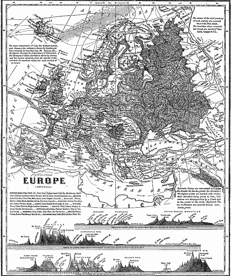
Description: A map from 1868 of Europe, showing the physical features, climate, and commercial resources of the region. Mountain chains are represented by lines of varying thickness, with the broader the line, the greater the elevation. The highest points of mountain chains are marked by circles, with volcanoes distinguished by a dot in the center of the circle. Elevations are given in feet above sea level. The mean temperature isotherms for January (solid line) and July (dashed line) are given with temperatures in degrees Fahrenheit. The direction of ocean currents is shown by arrows, and the figures attached indicate the velocity of the currents in nautical miles for each twenty–four hour period. The names of chief commercial products of each country are inserted, and locations of mineral deposits are indicated. Three cross– section charts at the bottom of the map show vertical profiles, from the south–west point of Ireland to North Cape, Norway, from the Atlantic to the Ural River between latitudes 45° and 49° North, and from the Strait of Gibraltar to the Caspian Sea.
Place Names: A Complete Map of Europe, France, �Germany, �Greece, �Italy, �Poland, �Portugal, �Romania, �Spain, �Sweden, �United Kingdo
ISO Topic Categories: oceans,
location,
inlandWaters,
elevation,
climatologyMeteorologyAtmosphere
Keywords: Europe (Physical), borders, �currents, �physical, �temperature, �topographical, �hydrological, �meteorological, topographical, country borders, climate,
temperature, currents, oceans,
location,
inlandWaters,
elevation,
climatologyMeteorologyAtmosphere, Unknown, 1868
Source: George W. Fitch , Outlines of Physical Geography (New York, NY: Ivison, Phinney, Blakeman & Company, 1868) 90-91
Map Credit: Courtesy the private collection of Roy Winkelman |
|