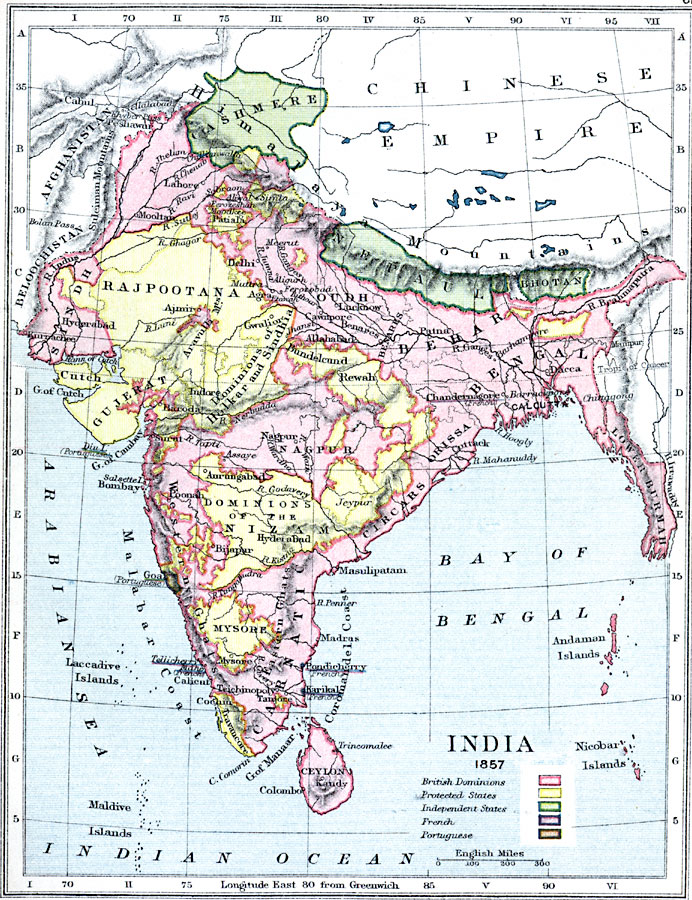
Description: A map of British India at the time of the Indian Rebellion of 1857. The map is color–coded to show the British dominions extending from the frontiers of Beloochistan and Afghanistan in the west to Lower Burmah (Myanmar) and the Irrawaddy River in the east, and including the Andaman Islands in the Bay of Bengal. The map also shows the protected states, the independent states of Cashmere, Nepaul (Nepal), and Bhotan (Bhutan), the French possessions of Chandernagore, Mahe, Tellicherry, Karikal, and Pondicherry, and the Portuguese possessions of Goa and Diu Island. The map shows major cities, terrain, and rivers of the region.
Place Names: India , Madras, �Pondicherry, �Ceylon, �Kandy�Colombo, �Calicut, �Teichinopoly, �Aurungabad, �Bombay, �Poonah, �Cuttack, �Calcutta, �Delhi, �Hyderabad, �Nepau
ISO Topic Categories: inlandWaters,
location,
boundaries,
oceans
Keywords: India at the time of the Indian Rebellion, physical, �political, �map of india in 1857 showing british dominions, protected states, independent states, french territory, portuguese, physical features,
topographical, country borders,
major political subdivisions, inlandWaters,
location,
boundaries,
oceans, Unknown, 1857
Source: Samuel Rawson Gardiner D.C.L., L.L.D., School Atlas of English History (London, England: Longmans, Green, and Co., 1914) 61
Map Credit: Courtesy the private collection of Roy Winkelman |
|