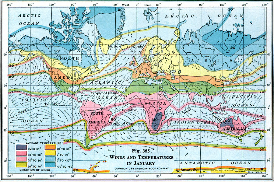
Description: A 1916 world map showing mean global winds and temperatures during the month of January. This map is color–coded to show mean January temperatures in degrees Fahrenheit for areas of land and along isotherms of the oceans, ranging from over 90° in southern Africa and Australia, to –30° to –50° in the northern hemisphere. The direction of prevailing January winds is shown, as well as the seasonal location of the Heat Equator.
Place Names: A Complete Map of Globes and Multi-continent, Africa, �Antarctica, �Australia, �Asia, �North America, �Europe, �South Americ
ISO Topic Categories: location,
oceans,
inlandWaters,
climatologyMeteorologyAtmosphere
Keywords: Global Winds and Temperatures in January, physical, �meteorological, kClimate, physical features, temperature,
winds, location,
oceans,
inlandWaters,
climatologyMeteorologyAtmosphere, Unknown, 1916
Source: Albert Perry Brigham & Charles T. McFarlane, Essentials of Geography (New York, NY: American Book Company, 1916) 254
Map Credit: Courtesy the private collection of Roy Winkelman |
|