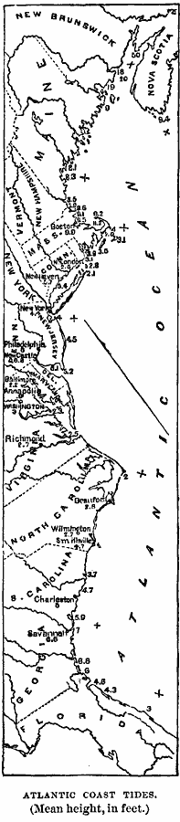
Description: A map from 1885 of the Atlantic coastline of North America showing typical tide heights, given in feet above mean sea level, at various points along the Atlantic seaboard and the general north–easterly direction of the daily tidal wave.
Place Names: Atlantic States, Florida, �Georgia, �South Carolina, �North Carolina, �Virginia, �New Jersey, �Delaware, �Maryland, �New York, �Connecticut, �Massachusetts, �Rhode Island, �Vermont, �New Hampshire, �Maine, �East Coast, �Atlantic States, �Atlantic Ocean, �Eastern Seaboa
ISO Topic Categories: boundaries,
inlandWaters,
location,
oceans
Keywords: Atlantic Coast Tides, physical, �political, physical features, major political subdivisions, boundaries,
inlandWaters,
location,
oceans, Unknown, 1885
Source: M. F. Maury, Physical Geography (New York, NY: University Publishing Company, 1885) 58
Map Credit: Courtesy the private collection of Roy Winkelman |
|