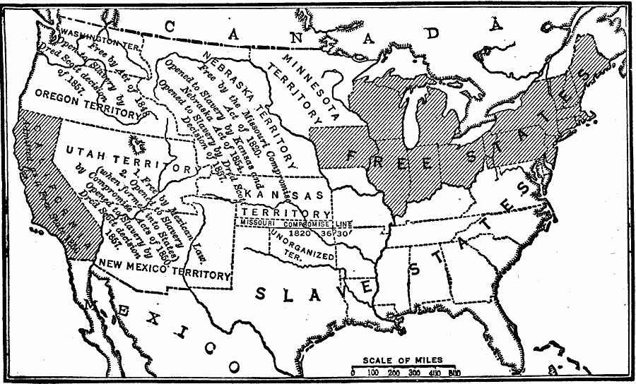
Description: A map of the United States showing the effects of the Compromise of 1850. The map is keyed to show the free states and slave states, and notes California admitted to the Union as a free state; the Nebraska Territory as free by the Missouri Compromise Act of 1820, opened to slavery by the Kansas–Nebraska Act of 1854, and opened to slavery by the Dred Scott Decision of 1857; the Oregon Territory free by the Act of 1848, opened to slavery by the Dred Scott Decision of 1857; the Utah and New Mexico territories free by Mexican law, opened to slavery by the Compromise Act of 1850 and by the Dred Scott Decision of 1857; and the Missouri Compromise Line.
Place Names: Growth of Nation, Slave States, �Free States, �Minnesota Territory, �Oregon Territory, �New Mexico Territory, �Utah Territory, �California, �Compromise of 185
ISO Topic Categories: oceans,
location,
inlandWaters,
boundaries
Keywords: Compromise of 1850, physical, �political, physical features, country borders,
major political subdivisions, oceans,
location,
inlandWaters,
boundaries, Unknown, 1850
Source: Robert Hall, Harriet Smither, and Clarence Ousley, A History of the United States (Dallas, TX: The Southern Publishing Company, 1920) 308
Map Credit: Courtesy the private collection of Roy Winkelman |
|