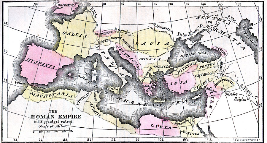
Description: A map of Europe and the Mediterranean showing the Roman Empire in its greatest extent. The map shows the European territories of Italia, Sicilia, Sardinia, Corsica, Rhætia, Vindelicia, Noricum, Pannonia, Dacia, Illyricum, Moesia, Macedonia, Thracia, Achaia, Creta, Cyprus, Gallia, Hispania, Baleares, lower Britannia, the Asia Minor territories of Bithynia, Pontus, Colchis, Asia, Cappadocia, Armenia, Cilicia, Mesopotamia, and Syria, and the northern Africa territories of &Aelig;gyptus, Libya, Africa (Carthage), Numidia, and Mauritania. The map shows the northern boundaries of the Empire along the Rhine, Danube, and Danaster (Dniester) rivers, the territories of the Scythia or Sarmatia, and many place names of the period, including Euxine Sea (Black Sea), Palus Moeotis (Moeotian Marshes, Moeotis being the Sea of Azov), and Columns of Hercules (Gibraltar).
Place Names: Regional Mediterranean, Asia, �Britannia, �Dacia, �Gallia, �Hispania, �Illyricum, �Mauritania, �Mediterranean Sea, �Syri
ISO Topic Categories: historical, kRomanEmpire, kWorldMedSea, kWorldAfroAsia, kWorldEurasia, kWorldEuroAfrica
Keywords: The Roman Empire, historical, kRomanEmpire, country borders, historical, kRomanEmpire, kWorldMedSea, kWorldAfroAsia, kWorldEurasia, kWorldEuroAfrica, Unknown, Circa 800 B.C.
Source: Marcius Willson, Willson's Outlines of History (New York, NY: Ivison & Phinney, 1859) 581
Map Credit: Courtesy the private collection of Roy Winkelman |
|