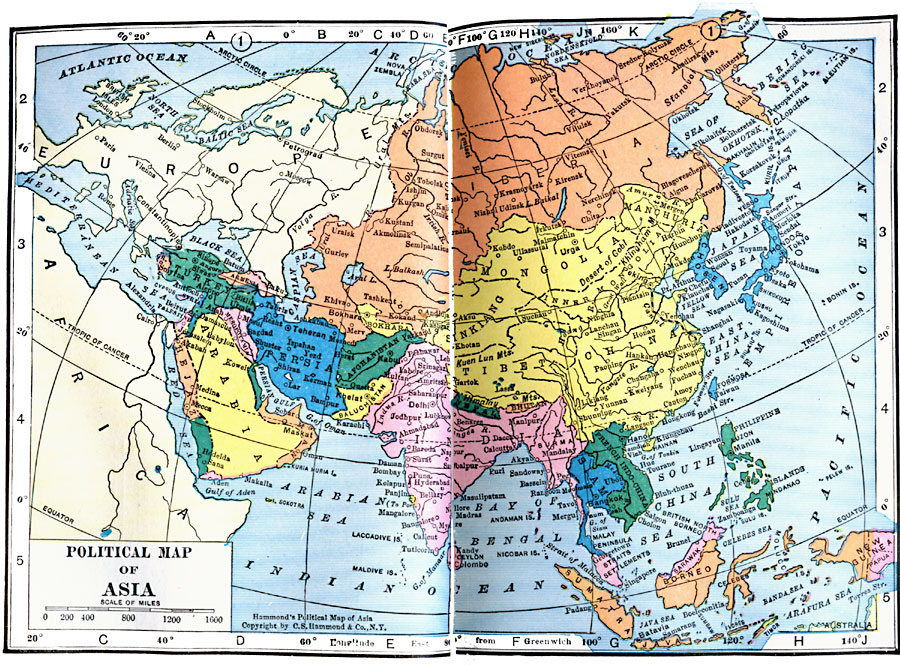
Description: A map of Asia from 1922 showing country boundaries at the time, major cities, rivers, lakes, and coastal features. This map does not reference the Russian territory, but shows Siberia. China is not referred to as an empire, but includes the territories of Manchuria, Mongolia, Inner Mongolia, Sinkiang, and Tibet, and India includes Burma (Myanmar). Country names of the period include Chosen (Korea), French Indochina (Vietnam, Laos, and Cambodia), Siam (Thailand), and Persia (Iran). Countries that no longer exist as such include Mesopotamia, Hejaz, Bokhara, and Baluchistan.
Place Names: A Complete Map of Asia, China, �India, �Japan, �Mongolia, �Phillipines, �Siberia, �Siam, �French Indo-China, �Persia, �Arabia, �Hejaz, �Afghanistan, �Baluchistan, �Napal,
ISO Topic Categories: boundaries,
location,
inlandWaters,
oceans
Keywords: Political Asia, physical, �political, physical features, country borders, boundaries,
location,
inlandWaters,
oceans, Unknown, 1922
Source: , Putnam's Handy Map Book (New York, NY: G. P. Putnam's Sons, 1922) 40-41
Map Credit: Courtesy the private collection of Roy Winkelman |
|