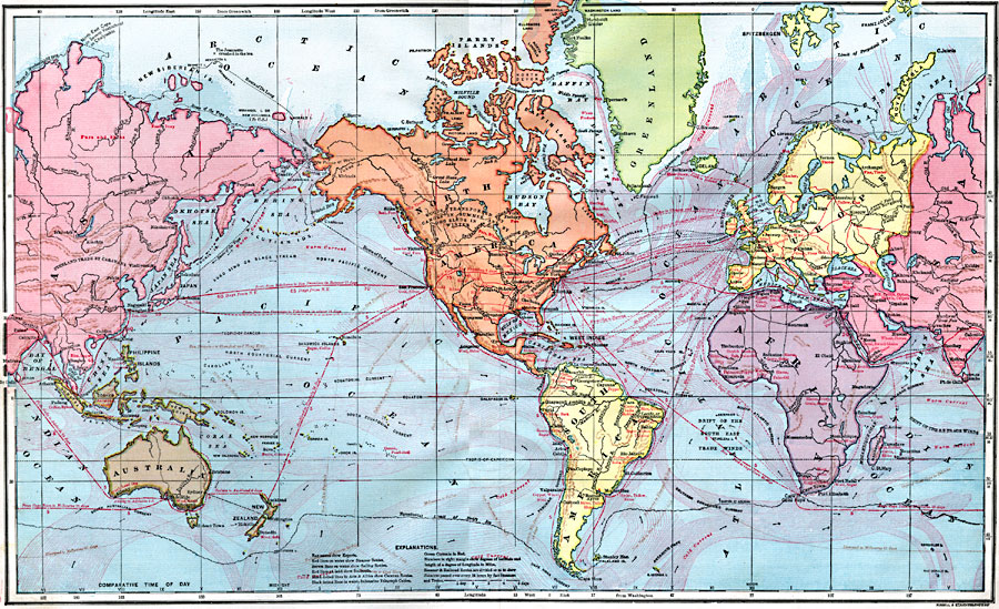
Description: A world map from 1872 showing trade routes by steamship, sailing vessel, and railway, and primary exports for various countries at the time. Red lines on water show steamer routes, brown lines show sailing routes, red lines on land show railroads, black dotted lines in Asia and Africa show caravan routes, and black dotted lines in water show submarine telegraph cables. The steamer and railroad routes are divided so as to show distances passed over every 24 hours by fast steamers and trains. Numbers in the right hand margin of the map show degrees of latitude and length of a degree of longitude in miles. Longitudes from Greenwich are shown at the top, and from Washington at the bottom of the map. Warm and cold ocean currents and drift of trade winds effecting shipping are shown, and the northern and southern limits of drift ice. The steamer route from Yokohama to San Francisco is shown for summer (17 days) and winter (16 days). This map also shows the region in Canada where goods are transported by canoes in summer and dog sled in winter. The map was revised to show the routes to find the Northwest Passage trade route, including the successful voyage of Adolf Erik Nordenskjold aboard the Vega (1879) and the ill-fated route of George De Long aboard the USS Jeannette (1879). Some of the trade export items shown are of period importance, including opium from Asia Minor and India, sword-blades from Arabia, and slaves and ivory from Africa.
Place Names: A Complete Map of Globes and Multi-continent, Africa, �Asia, �Australia, �Europe, �North America, �South Americ
ISO Topic Categories: boundaries,
inlandWaters,
location,
oceans,
transportation,
economy,
farming
Keywords: Commerce and Trade World Map, physical, �transportation, �hydrological, kEconomic, kTransportation, physical features, railroads,
water routes, currents, boundaries,
inlandWaters,
location,
oceans,
transportation,
economy,
farming, Unknown, 1872
Source: James Monteith, Comprehensive Geography (New York, New York: A. S. Barnes and Company, 1872) 96-97
Map Credit: Courtesy the private collection of Roy Winkelman |
|