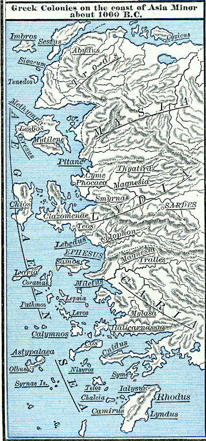
Description: Map of Greek colonies in the year 1000 B. C., showing settlements of the Hellenes around the coasts and on the Isles of the Aegean Sea, including the island colonies of Cyzicus, Imbros, Sestus, Tenedos, Methymna, Mytilene, Eresus, Chios, Iearia, Samos, Corasie, Lepisa, Pathmos, Leros, Calymnos, Cos, Astypalaea, Olbusa, Nisyros, Syrnae, Telos, Chaleia, Camirus, Ialysus, Lyndus, and Rhodus, the mainland colonies of Abydus, Sigaeum, Pitane, Cyme, Phocaea, Thyatira, Magnesia, Smyrna, Clazomenae, Teos, Lebedus, Sardes, Colophon, Ephesus, Tralles, Miletus, Mylasa, Halicarnassus, and Cnidus, and the Asia Minor territories of Troas, Mysia, Lydia, and Caria.
Place Names: Greece, Asia Minor, Aegean Islands
ISO Topic Categories: oceans,
location,
inlandWaters
Keywords: Greek Colonies on the Coast of Asia Minor, borders, �political, kAncientGreece, major political subdivisions, oceans,
location,
inlandWaters, Unknown, 1000 BC
Source: Robert H. Labberton, New Historical Atlas and General History (New York, NY: Townsend MacCoun, 1886) Plate V
Map Credit: Courtesy the private collection of Roy Winkelman |
|