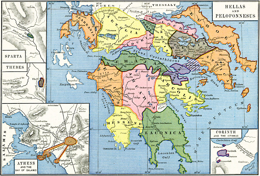
Description: Map of Hellas and Peloponnesus in 300 BC, during the Hellenistic Period after the death of Alexander the Great. The map is color–coded to show the political divisions of the region, including Acarnania, &Aelig;tolia, Locris, Doris, Phocis, Boeotia, Euboea, Attica, Megaris, Corinthia, Achaja, Elis, Arcadia, Messene, and Laconica. This map shows important cities of the time, and important battle sites with dates fought, including Marathon (490), Leuctra (377), Thermopylae (480), and Tanagra (456). Inset maps show the city–states of Sparta, Thebes, Corinth and the Wall of the Isthmus, and Athens and the Bay of Salamis.
Place Names: Greece, Acarnania, �Aetolia, �Arcadia, �Arcolis, �Athens, �Attica, �Boeotia, �Corinth, �Ellis, �Laconica, �Messene, �Phocia, �Sparta, �Thebe
ISO Topic Categories: oceans,
location,
inlandWaters,
boundaries
Keywords: Hellas and Peloponnesus, borders, �political, kAncientGreece, major political subdivisions, oceans,
location,
inlandWaters,
boundaries, Unknown, 300 BC
Source: Robert H. Labberton, New Historical Atlas and General History (New York, NY: Townsend MacCoun, 1886) Plate IX
Map Credit: Courtesy the private collection of Roy Winkelman |
|