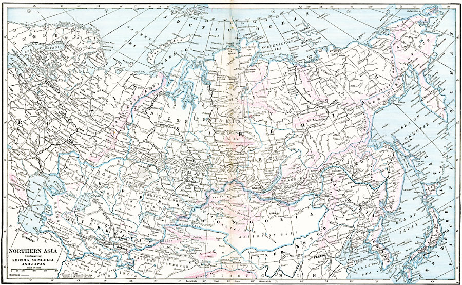
Description: A map from 1920 of northern Asia showing the political boundaries at the time. The map shows the Russian Empire in Asia east of the Ural Mountains and Volga River, including the provinces of Tobolsk, Yeniseisk, Yakutsk, Anadir and Maritime Provinces, Amur, Trans–Baikal, Irkutsk, Tomsk, Semipalatinsk, Akmolinsk, Turgai, Uralsk, Trans Caspian, Khiva, Semirechinsk, Sir Daria, Samarkand, Ferghana, and Bokhara. The Chinese provinces of Mongolia, Manchuria, and Inner Mongolia are shown, as well as the northern portion of the Japanese Empire and Chosen (Korea). The map shows major cities, towns, ports, railways, mountain systems, plateaus, plains and steppes, lakes, rivers, coastal features, and islands.
Place Names: Miscellaneous Asia, Amur, �Anadir, �Japan, �Korea, �Manchuria, �Mongolia,�Siberia, �Steppes, �Tomsk, �Turkesta
ISO Topic Categories: oceans,
location,
inlandWaters,
boundaries
Keywords: Northern Asia, borders, �political, �transportation, �physical, topographical,
physical features, country borders,
major political subdivisions, railroads,
water routes, oceans,
location,
inlandWaters,
boundaries, Unknown, 1920
Source: , The New Reference Atlas of the World - A New Series of Physical, Political and Historical Maps compiled from Government Surveys and exhibiting the Latest Results of Geographical Research (New York, NY: C. S. Hammond & Company, 1920) 56-57
Map Credit: Courtesy the private collection of Roy Winkelman |
|