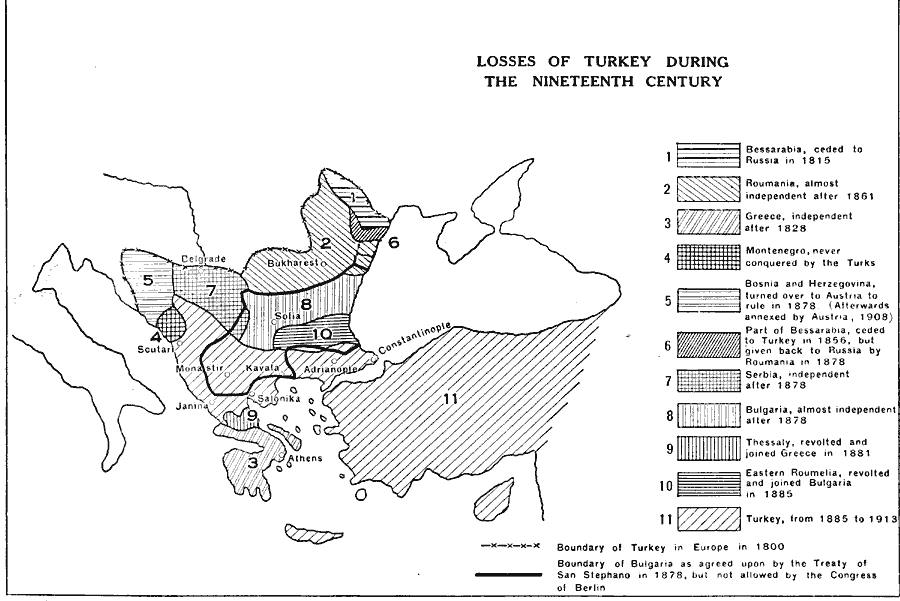
Description: A map showing the territorial losses of Turkey during the nineteenth century. This map shows the boundary of Turkey in Europe in 1800 and the boundary of Bulgaria as agreed upon by the Treaty of San Stephano in 1878, but not allowed by the Congress of Berlin, the territory of Bessarabia, ceded to Russia in 1815, the territory of Roumania, almost independent after 1861, Greece, independent after 1828, the territory of Montenegro, which was never conquered by the Turks, the territories of Bosnia and Herzegovina turned over to Austria to rule in 1878 (afterward annexed by Austria in 1908), the portion of Bessarabia ceded to Turkey in 1856, but returned to Russia by Roumania in 1878, Serbia, independent after 1878, Bulgaria, almost independent after 1878, Thessaly, which revolted and joined Greece in 1881, the territory of Roumelia, which revolted and joined Bulgaria in 1885, and the extent of Turkey from 1885 to 1913.
Place Names: Turkey, Bessarabia, �Roumania, �Greece, �Montenegro, �Bosnia, �Herzegovina, �Serbia, �Bulgaria, �Thessaly, �Roumelia, �Turkey, �Scutari, �Janina, �Belgrade, �Bukharest, �Constantinople, �Adrianople, �Sofia, �Athen
ISO Topic Categories: boundaries,
oceans,
location,
inlandWaters
Keywords: Losses of Turkey , physical, �political, �historical, physical features, country borders, boundaries,
oceans,
location,
inlandWaters, Unknown, 1800–1913
Source: L. P. Benezet, The Story of the Map of Europe (Chicago, IL: Scott, Foresman and Company, 1916) 169
Map Credit: Courtesy the private collection of Roy Winkelman |
|