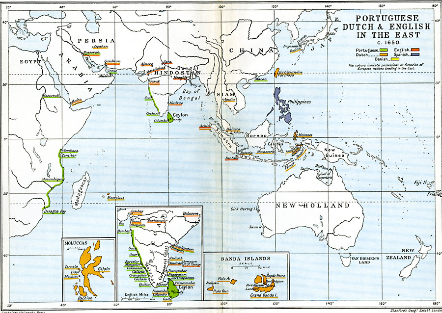
Description: A map of eastern Africa, southern Asia, and Indonesia showing the possessions of the Portuguese, Dutch, and English in the region around 1650. The map is color–coded to show territorial possessions at the time of the Portuguese in green, Dutch in tan, English in orange, Spanish in dark blue, and Danish in yellow. Major trade centers and seaports are shown, with the county or countries controlling trade indicated by the underlined color. Inset maps detail possessions in the Moluccas Islands, southern India and Sri Lanka, and the Banda Islands. Several place names reflect the period, such as Hindostan (India), Siam (Thailand), Formosa (Taiwan), Ceylon (Sri Lanka), New Holland (Australia), and Van Diemen's Land (Tazmania).
Place Names: Regional Indian Ocean, Arabia, �Australia, �Borneo, �China, �Egypt, �Hindostan, �New Guinea, �New Zealand, �Persia, �Philippine
ISO Topic Categories: political, kWorldIndian
Keywords: Portuguese, Dutch, and English Possessions in the East, political, local jurisdictions,
country borders,
major political subdivisions, political, kWorldIndian, Unknown, 1650
Source: Ward, Prothero, and Leathes, The Cambridge Modern History Atlas (New York, NY: The Macmillan Company, 1912)
Map Credit: Courtesy the private collection of Roy Winkelman |
|