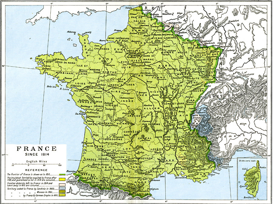
Description: A map of France between the Treaty of Paris (1814) that ended the War of the Sixth Coalition, and the Treaty of Frankfurt (1871) that ended the Franco–Prussian War. This map is color–coded to show the frontier of France in 1815, the insulated territories acquired by France (Montbeliard, Comtat Venaissin, and the Principality of Orange) after 1789, and guaranteed to her in 1814, the frontier districts left to France in 1814 and taken away in 1815 (Marienburg, Givet, and Saarlouis), the territory ceded to France by Sardinia in 1860 under the Treaty of Plombières between Napoleon III and Camillo Benso (Savoy and Nice), the territory ceded to France by Monaco in 1861, and the territories ceded by France to the German Empire (Alsace and Lorraine). The map also has an inset of the French controlled island of Corsica.
Place Names: France, Bordeaux, �Dunkerque, �Grenoble, �Lyon, �Nancy, �Nice, �Orleans, �Paris, �Starsbourg, �Tour
ISO Topic Categories: oceans,
location,
inlandWaters,
boundaries
Keywords: France, political, �historical, country borders,
local jurisdictions,
major political subdivisions, historical event, oceans,
location,
inlandWaters,
boundaries, Unknown, 1814–1871
Source: Ward, Prothero, and Leathes, The Cambridge Modern History Atlas (New York, NY: The Macmillan Company, 1912)
Map Credit: Courtesy the private collection of Roy Winkelman |
|